Premium Framed Print > Arts > Artists > T > John Tallis
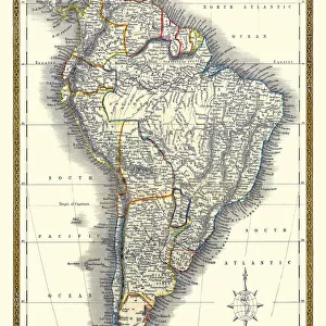
Premium Framed Print : Old Map of South America 1851 by John Tallis


![]()
Framed Photos from MapSeeker
Old Map of South America 1851 by John Tallis
A fine facimile artworked from an antique original map of South America, issued as part of the 1851 edition of John Tallis and Companys " The Illustrated Atlas and Modern History of the World"
Welcome to the Mapseeker Image library and enter an historic gateway to one of the largest on-line collections of Historic Maps, Nostalgic Views, Vista's and Panorama's from a World gone by.
Media ID 20347344
© Mapseeker Publishing Ltd
John Tallis John Tallis Map Tallis Tallis Map Southern America
14"x18" Premium Frame
Contemporary style Premium Wooden Frame with 8"x12" Print. Complete with 2" White Mat and 1.25" thick MDF frame. Printed on 260 gsm premium paper. Glazed with shatter proof UV coated acrylic glass. Backing is paper covered backing with rubber bumpers. Supplied ready to hang with a pre-installed sawtooth/wire hanger. Care Instructions: Spot clean with a damp cloth. Securely packaged in a clear plastic bag and envelope in a reinforced cardboard shipper
FSC Real Wood Frame and Double Mounted with White Conservation Mountboard - Professionally Made and Ready to Hang
Estimated Image Size (if not cropped) is 20.3cm x 30.4cm (8" x 12")
Estimated Product Size is 35.6cm x 45.8cm (14" x 18")
These are individually made so all sizes are approximate
Artwork printed orientated as per the preview above, with portrait (vertical) orientation to match the source image.
FEATURES IN THESE COLLECTIONS
> MapSeeker
> Maps of the Americas
> Maps of Central and South America
> Arts
> Artists
> T
> John Tallis
> Maps and Charts
> Related Images
> Maps and Charts
> World
> South America
> Related Images
Old Map of South America 1851 - A Glimpse into the Rich History of a Continent
EDITORS COMMENTS
. This print showcases an exquisite facsimile artworked from an antique original map of South America, dating back to 1851. Crafted by the renowned cartographer John Tallis and his company, this masterpiece was featured in their esteemed publication "The Illustrated Atlas and Modern History of the World". Transporting us back in time, this old map offers a fascinating glimpse into the intricate details and geographical accuracy prevalent during that era. Every stroke on this fine reproduction tells a story, capturing the essence of exploration and discovery that characterized South America's past. From the mighty Amazon rainforest to the majestic Andes Mountains, every corner of this diverse continent is meticulously depicted with precision. The names of cities, rivers, and mountain ranges are delicately inscribed alongside vibrant illustrations showcasing local flora and fauna. As we gaze upon this remarkable piece of history, we can't help but marvel at how much has changed over centuries. Yet amidst all these transformations lies an enduring spirit that still resonates today – one that celebrates cultural diversity, natural wonders, and untamed beauty. Whether you're a history enthusiast or simply captivated by South America's allure, let this evocative print transport you to a bygone era filled with tales waiting to be discovered. Embrace its charm as it serves as a reminder not only of our collective heritage but also as an inspiration for future explorations yet to
MADE IN THE USA
Safe Shipping with 30 Day Money Back Guarantee
FREE PERSONALISATION*
We are proud to offer a range of customisation features including Personalised Captions, Color Filters and Picture Zoom Tools
SECURE PAYMENTS
We happily accept a wide range of payment options so you can pay for the things you need in the way that is most convenient for you
* Options may vary by product and licensing agreement. Zoomed Pictures can be adjusted in the Cart.