Premium Framed Print > Arts > Photorealistic artworks > Detailed art pieces > Masterful detailing in art
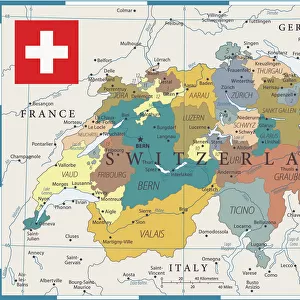
Premium Framed Print : Old Map of Switzerland 1852 by Henry George Collins


![]()
Framed Photos from MapSeeker
Old Map of Switzerland 1852 by Henry George Collins
This is a finely detailed map of Switzerland remastered from a rare Atlas of the World published in 1852 by Henry George Collins. Although these Henry Collins produced maps of the highest quality in his time unfortunately not the same could be said in terms of his business success. His maps were later obtained by the famous Stanford Map Company and used in their publications
Welcome to the Mapseeker Image library and enter an historic gateway to one of the largest on-line collections of Historic Maps, Nostalgic Views, Vista's and Panorama's from a World gone by.
Media ID 20347422
© Mapseeker Publishing Ltd
Collins Collins Atlas Collins Atlas Map Collins Map
14"x18" Premium Frame
Contemporary style Premium Wooden Frame with 8"x12" Print. Complete with 2" White Mat and 1.25" thick MDF frame. Printed on 260 gsm premium paper. Glazed with shatter proof UV coated acrylic glass. Backing is paper covered backing with rubber bumpers. Supplied ready to hang with a pre-installed sawtooth/wire hanger. Care Instructions: Spot clean with a damp cloth. Securely packaged in a clear plastic bag and envelope in a reinforced cardboard shipper
FSC Real Wood Frame and Double Mounted with White Conservation Mountboard - Professionally Made and Ready to Hang
Estimated Image Size (if not cropped) is 30.4cm x 20.3cm (12" x 8")
Estimated Product Size is 45.8cm x 35.6cm (18" x 14")
These are individually made so all sizes are approximate
Artwork printed orientated as per the preview above, with landscape (horizontal) orientation to match the source image.
FEATURES IN THESE COLLECTIONS
> MapSeeker
> Maps of Europe
> Maps of Switzerland PORTFOLIO
> Arts
> Photorealistic artworks
> Detailed art pieces
> Masterful detailing in art
> Europe
> Switzerland
> Maps
> Europe
> Switzerland
> Posters
> Europe
> Switzerland
> Related Images
> Maps and Charts
> Switzerland
> Maps and Charts
> World
EDITORS COMMENTS
This beautifully preserved print showcases an exquisite "Old Map of Switzerland 1852" by the talented cartographer, Henry George Collins. Remastered from a rare Atlas of the World published in 1852, this map offers a glimpse into the intricate details and craftsmanship that characterized Collins' work during his time. While renowned for producing maps of unparalleled quality, Collins unfortunately did not achieve the same level of success in his business ventures. However, fate smiled upon these remarkable creations as they were later acquired by none other than the prestigious Stanford Map Company. Recognizing their value and historical significance, Stanford incorporated these maps into their own publications. The "Old Map of Switzerland 1852" transports us back to a bygone era when cartography was both an art form and a scientific endeavor. With its meticulous depiction of geographical features, towns, rivers, and mountain ranges across Switzerland's picturesque landscape, this vintage map provides invaluable insights into the country's past. Whether you are an avid collector or simply captivated by history's allure, this print is sure to be a cherished addition to any space. Let it transport you to another time as you marvel at Collins' attention to detail and appreciate the enduring beauty of Switzerland through this piece of cartographic artistry.
MADE IN THE USA
Safe Shipping with 30 Day Money Back Guarantee
FREE PERSONALISATION*
We are proud to offer a range of customisation features including Personalised Captions, Color Filters and Picture Zoom Tools
SECURE PAYMENTS
We happily accept a wide range of payment options so you can pay for the things you need in the way that is most convenient for you
* Options may vary by product and licensing agreement. Zoomed Pictures can be adjusted in the Cart.