Premium Framed Print > Europe > United Kingdom > Wales > Maps
Premium Framed Print : Map / England & Wales 9C


![]()
Framed Photos from Mary Evans Picture Library
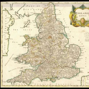
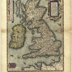
Map / England & Wales 9C
England and Wales during the Saxon era
Mary Evans Picture Library makes available wonderful images created for people to enjoy over the centuries
Media ID 573978
© Mary Evans Picture Library 2015 - https://copyrighthub.org/s0/hub1/creation/maryevans/MaryEvansPictureID/10009510
14"x16" Premium Frame
Contemporary style Premium Wooden Frame with 8"x10" Print. Complete with 2" White Mat and 1.25" thick MDF frame. Printed on 260 gsm premium paper. Glazed with shatter proof UV coated acrylic glass. Backing is paper covered backing with rubber bumpers. Supplied ready to hang with a pre-installed sawtooth/wire hanger. Care Instructions: Spot clean with a damp cloth. Securely packaged in a clear plastic bag and envelope in a reinforced cardboard shipper
FSC Real Wood Frame and Double Mounted with White Conservation Mountboard - Professionally Made and Ready to Hang
Estimated Image Size (if not cropped) is 20.3cm x 25.4cm (8" x 10")
Estimated Product Size is 35.6cm x 40.6cm (14" x 16")
These are individually made so all sizes are approximate
Artwork printed orientated as per the preview above, with portrait (vertical) orientation to match the source image.
FEATURES IN THESE COLLECTIONS
> Mary Evans Prints Online
> Maps
> Europe
> United Kingdom
> England
> Maps
> Europe
> United Kingdom
> England
> Posters
> Europe
> United Kingdom
> Wales
> Maps
> Europe
> United Kingdom
> Wales
> Posters
> Europe
> United Kingdom
> Wales
> Related Images
> Maps and Charts
> Early Maps
> Maps and Charts
> Related Images
> Maps and Charts
> Wales
EDITORS COMMENTS
This print of a map titled "England & Wales 9C" transports us back in time to the Saxon era, providing a glimpse into the historical landscape of Britain during the 9th century. The intricate details and ancient borders depicted on this map offer a fascinating insight into the political and geographical makeup of England and Wales centuries ago.
As we study this piece, we are reminded of the rich history and cultural heritage that have shaped these lands over generations. The names of towns, rivers, and regions evoke a sense of nostalgia for a bygone era when kingdoms rose and fell, battles were fought, and societies evolved.
The craftsmanship evident in this map is truly remarkable, showcasing the artistry and precision required to create such detailed cartography without modern technology. Each line drawn represents not just physical geography but also political boundaries and societal structures that defined life in England and Wales during this period.
Through this print from Mary Evans Picture Library, we are able to connect with our past in a tangible way, appreciating the complexities of our shared history while gaining a deeper understanding of how our present-day landscapes came to be. It serves as a reminder that beneath our modern world lies layers upon layers of stories waiting to be discovered.
MADE IN THE USA
Safe Shipping with 30 Day Money Back Guarantee
FREE PERSONALISATION*
We are proud to offer a range of customisation features including Personalised Captions, Color Filters and Picture Zoom Tools
SECURE PAYMENTS
We happily accept a wide range of payment options so you can pay for the things you need in the way that is most convenient for you
* Options may vary by product and licensing agreement. Zoomed Pictures can be adjusted in the Cart.