Premium Framed Print > Mary Evans Prints Online > New Images July 2020
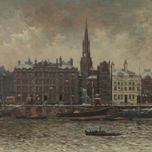
Premium Framed Print : SURVEYING LEVELS


![]()
Framed Photos from Mary Evans Picture Library
SURVEYING LEVELS
A whole selection of different surveying instruments, and diagrams relating to their specific uses. Date: 1810
Mary Evans Picture Library makes available wonderful images created for people to enjoy over the centuries
Media ID 20150419
© Bubblepunk
1810 Accuracy Diagrams Dials Instruments Levels Relating Selection Specific Surveying Graphs Pendulums
16"x16" Premium Frame
Contemporary style Premium Wooden Frame with 10"x10" Print. Complete with 2" White Mat and 1.25" thick MDF frame. Printed on 260 gsm premium paper. Glazed with shatter proof UV coated acrylic glass. Backing is paper covered backing with rubber bumpers. Supplied ready to hang with a pre-installed sawtooth/wire hanger. Care Instructions: Spot clean with a damp cloth. Securely packaged in a clear plastic bag and envelope in a reinforced cardboard shipper
FSC Real Wood Frame and Double Mounted with White Conservation Mountboard - Professionally Made and Ready to Hang
Estimated Image Size (if not cropped) is 25.4cm x 25.4cm (10" x 10")
Estimated Product Size is 40.6cm x 40.6cm (16" x 16")
These are individually made so all sizes are approximate
Artwork printed orientated as per the preview above, with landscape (horizontal) or portrait (vertical) orientation to match the source image.
EDITORS COMMENTS
This print from 1810 showcases an impressive collection of surveying levels and accompanying diagrams, offering a fascinating glimpse into the world of land measurement and cartography from the early 19th century. The image is adorned with an array of surveying instruments, each meticulously rendered in intricate detail. At the heart of the scene lies a surveying level, a device used to determine the relative heights of points in the landscape. The level's horizontal vial, filled with mercury, ensures a level surface, while the graduated scale allows for precise measurements. Adjacent to the level, various pendulums and dials are depicted, employed to compensate for small variations in the instrument's position and temperature. The print also features a selection of graphs and diagrams, which illustrate the specific uses and applications of these surveying tools. For instance, one diagram demonstrates the relationship between the angle of inclination and the height difference between two points, while another illustrates the concept of the vertical angle. These instruments and diagrams played a crucial role in the scientific pursuit of accurate land measurement, enabling the creation of detailed topographical maps and surveys. The precision and dedication to detail evident in this print reflect the importance of surveying in the fields of engineering, geodesy, and cartography during the early 19th century. This image offers a unique window into the past, revealing the intricacies of surveying techniques and the scientific advancements of the time.
MADE IN THE USA
Safe Shipping with 30 Day Money Back Guarantee
FREE PERSONALISATION*
We are proud to offer a range of customisation features including Personalised Captions, Color Filters and Picture Zoom Tools
SECURE PAYMENTS
We happily accept a wide range of payment options so you can pay for the things you need in the way that is most convenient for you
* Options may vary by product and licensing agreement. Zoomed Pictures can be adjusted in the Cart.