Premium Framed Print > Historic > Ancient civilizations > Ancient Greece > Greek history
Premium Framed Print : Ancient Greek empire


Framed Photos from North Wind
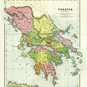
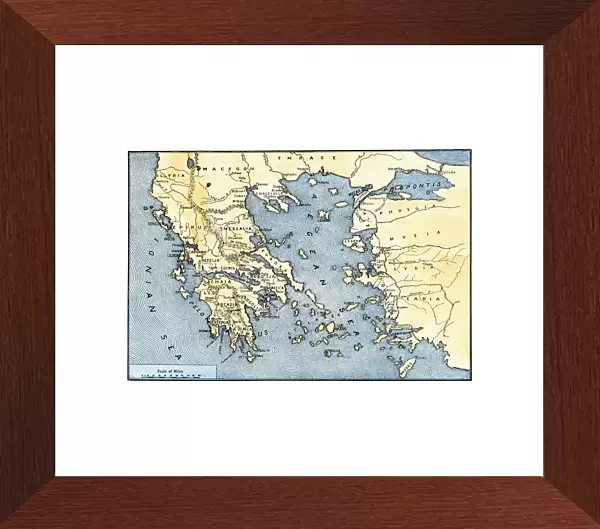
Ancient Greek empire
Map of ancient Greece and its colonies.
Hand-colored woodcut of a 19th-century illlustration
North Wind Picture Archives brings history to life with stock images and hand-colored illustrations
Media ID 5878112
© North Wind Picture Archives
Ancient Ancient Civilization Ancient Greece Ancient Greek Ancient History Antiquity Asia Minor Civilization Classical Classical Civilization Europe European Greece Greek Turkey Aegean Sea Peloponnesus Rhodes Thrace
14"x18" Premium Frame
Contemporary style Premium Wooden Frame with 8"x12" Print. Complete with 2" White Mat and 1.25" thick MDF frame. Printed on 260 gsm premium paper. Glazed with shatter proof UV coated acrylic glass. Backing is paper covered backing with rubber bumpers. Supplied ready to hang with a pre-installed sawtooth/wire hanger. Care Instructions: Spot clean with a damp cloth. Securely packaged in a clear plastic bag and envelope in a reinforced cardboard shipper
FSC Real Wood Frame and Double Mounted with White Conservation Mountboard - Professionally Made and Ready to Hang
Estimated Image Size (if not cropped) is 30.4cm x 20.3cm (12" x 8")
Estimated Product Size is 45.8cm x 35.6cm (18" x 14")
These are individually made so all sizes are approximate
Artwork printed orientated as per the preview above, with landscape (horizontal) orientation to match the source image.
FEATURES IN THESE COLLECTIONS
> North Wind Picture Archives
> Ancient history
> North Wind Picture Archives
> Maps
> Asia
> Related Images
> Asia
> Turkey
> Related Images
> Europe
> Greece
> Related Images
> Historic
> Ancient civilizations
> Ancient Greece
> Greek history
> Historic
> Ancient civilizations
> Ancient Greece
> Historic
> Ancient civilizations
> Maps and Charts
> Early Maps
EDITORS COMMENTS
This print showcases a hand-colored woodcut of an illustration from the 19th century, depicting the vast and influential Ancient Greek empire. The map beautifully highlights not only ancient Greece itself but also its colonies, offering a glimpse into the expansive reach of this historic civilization. The intricate details on this vintage piece transport us back to classical times, allowing us to appreciate the rich history and cultural significance of ancient Greece. From its birthplace in Europe, we can trace the empire's expansion across Asia Minor (modern-day Turkey) and Thrace. The Aegean Sea acts as a connecting thread between these regions, emphasizing their interconnectedness during that era. Notable landmarks such as Rhodes and Peloponnesus are prominently featured on this map, reminding us of their importance within ancient Greek society. As we explore each corner of this illustration with awe, it becomes evident how deeply rooted classical civilization was in every aspect of life during those times. With its vibrant colors and meticulous artistry, this print serves as both a historical artifact and an artistic masterpiece. It invites us to delve into ancient Greece's remarkable past while appreciating the skillful craftsmanship behind creating such detailed illustrations. Whether you're an enthusiast for ancient history or simply captivated by timeless beauty, this image is sure to spark curiosity about one of humanity's most significant civilizations – Ancient Greece.
MADE IN THE USA
Safe Shipping with 30 Day Money Back Guarantee
FREE PERSONALISATION*
We are proud to offer a range of customisation features including Personalised Captions, Color Filters and Picture Zoom Tools
SECURE PAYMENTS
We happily accept a wide range of payment options so you can pay for the things you need in the way that is most convenient for you
* Options may vary by product and licensing agreement. Zoomed Pictures can be adjusted in the Cart.