Premium Framed Print > Europe > United Kingdom > Scotland > Maps
Premium Framed Print : GGBR2A-00076


![]()
Framed Photos from North Wind
GGBR2A-00076
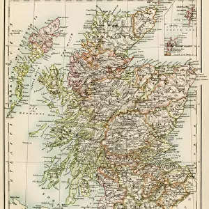
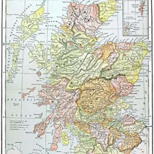
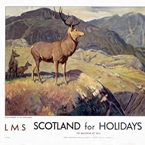
Map of Scotland in the 1520s, showing territories of the Highland Clans.
Printed color lithograph of a 19th century illustration
North Wind Picture Archives brings history to life with stock images and hand-colored illustrations
Media ID 5879160
© North Wind Picture Archives
1500s 16th Century British Europe Great Britain Medieval Scot Scot Land Scottish Territory Clan Highlander Scotch
14"x16" Premium Frame
Contemporary style Premium Wooden Frame with 8"x10" Print. Complete with 2" White Mat and 1.25" thick MDF frame. Printed on 260 gsm premium paper. Glazed with shatter proof UV coated acrylic glass. Backing is paper covered backing with rubber bumpers. Supplied ready to hang with a pre-installed sawtooth/wire hanger. Care Instructions: Spot clean with a damp cloth. Securely packaged in a clear plastic bag and envelope in a reinforced cardboard shipper
FSC Real Wood Frame and Double Mounted with White Conservation Mountboard - Professionally Made and Ready to Hang
Estimated Image Size (if not cropped) is 20.3cm x 25.4cm (8" x 10")
Estimated Product Size is 35.6cm x 40.6cm (14" x 16")
These are individually made so all sizes are approximate
Artwork printed orientated as per the preview above, with portrait (vertical) orientation to match the source image.
FEATURES IN THESE COLLECTIONS
> North Wind Picture Archives
> British history
> North Wind Picture Archives
> Maps
> Arts
> Art Movements
> Medieval Art
> Europe
> France
> Canton
> Landes
> Europe
> United Kingdom
> Scotland
> Highlands
> Related Images
> Europe
> United Kingdom
> Scotland
> Maps
> Europe
> United Kingdom
> Scotland
> Posters
> Europe
> United Kingdom
> Scotland
> Related Images
> Maps and Charts
> Related Images
EDITORS COMMENTS
This 19th-century lithograph print takes us back in time to the 1520s, offering a glimpse into the territories of the Highland Clans in Scotland. The intricate map showcases the rich history and medieval heritage of this great nation. With its vibrant printed colors, every detail comes to life, transporting us to an era when clans and their territories played a significant role in Scottish society. The illustration provides a fascinating insight into the complex web of clan affiliations and territorial boundaries that defined Scotland during this period. It serves as a visual representation of power struggles, alliances, and cultural identities that shaped the destiny of these proud highlanders. As we explore this vintage artwork, one cannot help but marvel at how it captures both historical accuracy and artistic beauty. The meticulous craftsmanship transports us through time, allowing us to appreciate not only the geography but also the artistry behind cartography during those times. This remarkable piece is more than just an illustration; it is a testament to Scottish history and European artistry. It reminds us of our shared past while igniting curiosity about what life was like for these brave Scots who called themselves highlanders. Whether you are fascinated by genealogy or simply captivated by ancient maps, this print offers an enchanting window into Scotland's past - a treasure for any history enthusiast or lover of fine art alike.
MADE IN THE USA
Safe Shipping with 30 Day Money Back Guarantee
FREE PERSONALISATION*
We are proud to offer a range of customisation features including Personalised Captions, Color Filters and Picture Zoom Tools
SECURE PAYMENTS
We happily accept a wide range of payment options so you can pay for the things you need in the way that is most convenient for you
* Options may vary by product and licensing agreement. Zoomed Pictures can be adjusted in the Cart.