Premium Framed Print > North America > United States of America > New York > New York > Maps
Premium Framed Print : Erie Canal route


![]()
Framed Photos from North Wind
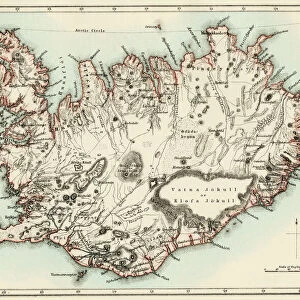
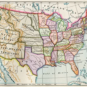
Erie Canal route
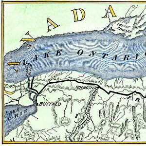
Map of the Erie Canal across New York state, 1800s.
Hand-colored woodcut of a 19th-century illustration
North Wind Picture Archives brings history to life with stock images and hand-colored illustrations
Media ID 5882693
© North Wind Picture Archives
Canal Erie Canal Hudson River Lake Erie Lake Ontario New York Transportation Travel
14"x18" Premium Frame
Contemporary style Premium Wooden Frame with 8"x12" Print. Complete with 2" White Mat and 1.25" thick MDF frame. Printed on 260 gsm premium paper. Glazed with shatter proof UV coated acrylic glass. Backing is paper covered backing with rubber bumpers. Supplied ready to hang with a pre-installed sawtooth/wire hanger. Care Instructions: Spot clean with a damp cloth. Securely packaged in a clear plastic bag and envelope in a reinforced cardboard shipper
FSC Real Wood Frame and Double Mounted with White Conservation Mountboard - Professionally Made and Ready to Hang
Estimated Image Size (if not cropped) is 30.4cm x 20.3cm (12" x 8")
Estimated Product Size is 45.8cm x 35.6cm (18" x 14")
These are individually made so all sizes are approximate
Artwork printed orientated as per the preview above, with landscape (horizontal) orientation to match the source image.
FEATURES IN THESE COLLECTIONS
> North Wind Picture Archives
> Maps
> Arts
> Landscape paintings
> Waterfall and river artworks
> River artworks
> North America
> Related Images
> North America
> United States of America
> New York
> Buffalo
> North America
> United States of America
> New York
> New York
> Maps
> North America
> United States of America
> New York
> Related Images
EDITORS COMMENTS
This print showcases a hand-colored woodcut of a 19th-century illustration depicting the Erie Canal route across New York state. The vintage charm emanating from this piece instantly transports us back to an era where American heritage and tradition were at their peak. With intricate details, the map highlights the extensive transportation network that connected Lake Ontario, Lake Erie, and the Hudson River. The significance of this historic canal cannot be overstated. Serving as a vital artery for trade and travel during its time, it played an instrumental role in shaping the history of North America. As we gaze upon this artful representation, we are reminded of the countless journeys made along these waterways by pioneers seeking new opportunities or simply exploring uncharted territories. The artist's skillful use of colors brings life to every inch of this map, allowing us to appreciate not only its historical value but also its artistic merit. From Buffalo NY to Troy NY, each town along the canal is meticulously labeled with precision and care. As we admire this remarkable piece, let us reflect on how far transportation has come since those early days. The Erie Canal stands as a testament to human ingenuity and determination in conquering vast distances through innovative means. Whether you are a history enthusiast or simply captivated by art from yesteryears, this print will undoubtedly add depth and character to any space it graces.
MADE IN THE USA
Safe Shipping with 30 Day Money Back Guarantee
FREE PERSONALISATION*
We are proud to offer a range of customisation features including Personalised Captions, Color Filters and Picture Zoom Tools
SECURE PAYMENTS
We happily accept a wide range of payment options so you can pay for the things you need in the way that is most convenient for you
* Options may vary by product and licensing agreement. Zoomed Pictures can be adjusted in the Cart.