Premium Framed Print > Arts > Artists > O > Oceanic Oceanic
Premium Framed Print : EXPL2A-00065


![]()
Framed Photos from North Wind
EXPL2A-00065
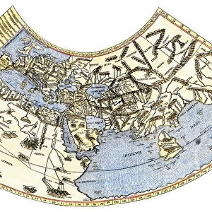
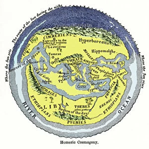
World map of the flat earth printed by Beatus Rhenanus Bildaus Rheinau early 1500s - North is left, Mediterranean Sea middle
Printed color lithograph reproduction 19th century
North Wind Picture Archives brings history to life with stock images and hand-colored illustrations
Media ID 5882012
© North Wind Picture Archives
1500s 16th Century Adventure Africa Asia Atlantic Ocean Cartography Chart Discover Europe Exploration Explore Fish Flat Earth Maritime Mediterranean Mediterranean Sea Navigation Ocean Travel World Beatus Libia Libya
14"x18" Premium Frame
Contemporary style Premium Wooden Frame with 8"x12" Print. Complete with 2" White Mat and 1.25" thick MDF frame. Printed on 260 gsm premium paper. Glazed with shatter proof UV coated acrylic glass. Backing is paper covered backing with rubber bumpers. Supplied ready to hang with a pre-installed sawtooth/wire hanger. Care Instructions: Spot clean with a damp cloth. Securely packaged in a clear plastic bag and envelope in a reinforced cardboard shipper
FSC Real Wood Frame and Double Mounted with White Conservation Mountboard - Professionally Made and Ready to Hang
Estimated Image Size (if not cropped) is 30.4cm x 20.3cm (12" x 8")
Estimated Product Size is 45.8cm x 35.6cm (18" x 14")
These are individually made so all sizes are approximate
Artwork printed orientated as per the preview above, with landscape (horizontal) orientation to match the source image.
FEATURES IN THESE COLLECTIONS
> North Wind Picture Archives
> Maps
> Africa
> Libya
> Related Images
> Africa
> Related Images
> Animals
> Fishes
> Related Images
> Arts
> Artists
> O
> Oceanic Oceanic
> Asia
> Related Images
> Maps and Charts
> Early Maps
> Maps and Charts
> Flat Earth
> Maps and Charts
> Related Images
EDITORS COMMENTS
This vintage print takes us back to the early 1500s when cartography was still in its infancy. Titled "EXPL2A-00065" it showcases a world map of the flat earth, printed by Beatus Rhenanus Bildaus Rheinau. The unique aspect of this map is that North is depicted on the left side, contrary to our modern conventions. The Mediterranean Sea occupies the central position, serving as a pivotal point for navigation and trade routes during that era. The lithograph reproduction from the 19th century beautifully captures the intricate details and vibrant colors of the original artwork. As we explore this historic illustration, we can't help but notice various elements that reflect both adventure and maritime culture. Fish swim gracefully through oceans while ships sail across vast waters, symbolizing exploration and discovery. The chart encompasses Africa, Asia, Europe, and even Libya (Libia), providing a glimpse into how these regions were perceived at that time. It offers an intriguing insight into early cartography techniques and highlights how knowledge about our planet has evolved over centuries. This artful depiction serves as a reminder of humanity's curiosity about the world around us throughout history. Whether used for educational purposes or simply admired for its aesthetic appeal, this print invites us to embark on a journey through time where imagination meets reality.
MADE IN THE USA
Safe Shipping with 30 Day Money Back Guarantee
FREE PERSONALISATION*
We are proud to offer a range of customisation features including Personalised Captions, Color Filters and Picture Zoom Tools
SECURE PAYMENTS
We happily accept a wide range of payment options so you can pay for the things you need in the way that is most convenient for you
* Options may vary by product and licensing agreement. Zoomed Pictures can be adjusted in the Cart.