Premium Framed Print > Maps and Charts > Turkey
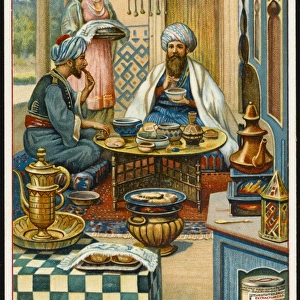
Premium Framed Print : The new world revealed to Islam in 1513. The map of the Atlantic, work of Admiral


![]()
Framed Photos from TopFoto
The new world revealed to Islam in 1513. The map of the Atlantic, work of Admiral
The new world revealed to Islam in 1513. The map of the Atlantic, work of Admiral Piri Reis, the celebrated Turkish cartographer. The map has recently been the subject of controversy and now shown to have been drawn some ten years only after Columbuss discovery
TopFoto independent historic photographs and images all subjects and eras
Media ID 10978319
© TopFoto.co.uk
16th Century Boat Chart Ship Cartographer Ottoman Sea Chart Turk
14"x16" Premium Frame
Contemporary style Premium Wooden Frame with 8"x10" Print. Complete with 2" White Mat and 1.25" thick MDF frame. Printed on 260 gsm premium paper. Glazed with shatter proof UV coated acrylic glass. Backing is paper covered backing with rubber bumpers. Supplied ready to hang with a pre-installed sawtooth/wire hanger. Care Instructions: Spot clean with a damp cloth. Securely packaged in a clear plastic bag and envelope in a reinforced cardboard shipper
FSC Real Wood Frame and Double Mounted with White Conservation Mountboard - Professionally Made and Ready to Hang
Estimated Image Size (if not cropped) is 20.3cm x 25.4cm (8" x 10")
Estimated Product Size is 35.6cm x 40.6cm (14" x 16")
These are individually made so all sizes are approximate
Artwork printed orientated as per the preview above, with portrait (vertical) orientation to match the source image.
FEATURES IN THESE COLLECTIONS
> Asia
> Turkey
> Related Images
> Maps and Charts
> Related Images
> Maps and Charts
> World
> Transportation
> Ships and Boats
> TopFoto
> Landscapes
The New World Unveiled - A Glimpse into Islamic Cartography in 1513
EDITORS COMMENTS
. This print showcases a remarkable piece of history, revealing the map of the Atlantic as seen through the eyes of Admiral Piri Reis, an esteemed Turkish cartographer. Crafted during the 16th century, this chart offers a unique perspective on global exploration and maritime navigation. What makes this map truly intriguing is its controversial nature. It was discovered that Admiral Piri Reis had drawn it merely ten years after Christopher Columbus's groundbreaking discovery of the New World. This revelation has sparked debates among historians and scholars worldwide, questioning how such knowledge could have reached Ottoman territories so swiftly. The intricate details depicted on this maritime diagram are awe-inspiring. Delicate strokes trace coastlines, while meticulously placed symbols represent islands and unknown lands waiting to be explored. The presence of ships and boats further emphasizes the significance of seafaring in uncovering new horizons during that era. As we delve into this visual masterpiece by Archive, we gain insight into not only Admiral Piri Reis's exceptional skills as a cartographer but also his contribution to expanding Islamic knowledge about faraway lands beyond their known world. This photograph serves as a reminder that historical discoveries often challenge our preconceived notions and ignite curiosity about our shared human journey across time and space.
MADE IN THE USA
Safe Shipping with 30 Day Money Back Guarantee
FREE PERSONALISATION*
We are proud to offer a range of customisation features including Personalised Captions, Color Filters and Picture Zoom Tools
SECURE PAYMENTS
We happily accept a wide range of payment options so you can pay for the things you need in the way that is most convenient for you
* Options may vary by product and licensing agreement. Zoomed Pictures can be adjusted in the Cart.