Northern hemisphere map, 16th Century

![]()
Wall Art and Photo Gifts from Science Photo Library
Northern hemisphere map, 16th Century
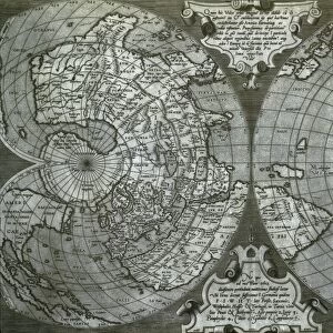
Northern hemisphere. A 16th century map of the Northern Hemisphere in a circular projection. The centre of the map is the north pole. Europe and northern Africa is in the upper left, the Middle East at left, India at lower left, south-east Asia at bottom and North America at right. Inscribed at upper right are the family names mentioned in the Book of Genesis, the supposed seats of those families being marked on the map at left. This comes from a fold-out plate from A concent of scripture by Hugh Broughton, published in London between 1587 and 1591
Science Photo Library features Science and Medical images including photos and illustrations
Media ID 6317567
© Todd-White Art Photography
1500s 16th Century Africa America Bible Biblical Book Chart Circular Families Family Genesis Hemisphere India Indian Middle East North Northern Polar Projection Mono Chrome Scripture Sub Continent
EDITORS COMMENTS
This print takes us back in time to the 16th century, showcasing a meticulously crafted map of the Northern Hemisphere. In this circular projection, the north pole takes center stage, surrounded by a wealth of geographical information. The upper left corner reveals Europe and northern Africa, while the Middle East finds its place on the left side. Lower left showcases India with its rich history and culture, while southeast Asia occupies the bottom portion of this intricate chart. Finally, North America graces the right side. What makes this map truly fascinating is its connection to biblical references found in the Book of Genesis. Inscribed at the upper right are family names mentioned in this sacred text, each believed to have their own designated seat marked on the map's left side. Originally part of Hugh Broughton's "A concent of scripture" published between 1587 and 1591 in London, this fold-out plate offers a glimpse into how people perceived geography during that era. Preserved through time as a monochrome print by Todd-White Art Photography from Science Photo Library, this historical artifact not only serves as an educational tool but also invites us to appreciate how our understanding of maps and continents has evolved throughout centuries.
MADE IN THE USA
Safe Shipping with 30 Day Money Back Guarantee
FREE PERSONALISATION*
We are proud to offer a range of customisation features including Personalised Captions, Color Filters and Picture Zoom Tools
SECURE PAYMENTS
We happily accept a wide range of payment options so you can pay for the things you need in the way that is most convenient for you
* Options may vary by product and licensing agreement. Zoomed Pictures can be adjusted in the Cart.