Home > Arts > Artists > S > John Speed
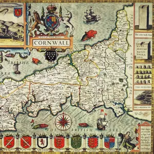
John Speeds map of Staffordshire, 1611

![]()
Wall Art and Photo Gifts from Sheffield City Archives
John Speeds map of Staffordshire, 1611
Image from Theatre of the Empire of Great Britaine presenting an exact geography of the Kingdomes of Ireland, Scotland, Ireland, and the Iles adioyning with The Shires, Hundreds, Cities and Shire Towns, within ye Kingdome of England, divided and described by John Speed (original at Sheffield Libraries: 914.2 SQ).
Note this image is of a genuine 400-year-old map from a tightly bound volume. It shows some wear and tear as well as the binding in the middle of the image
Sheffield City Archives and Local Studies Library has an unrivalled collection of images of Sheffield, England
Media ID 26401418
© Sheffield City Council - All Rights Reserved
FEATURES IN THESE COLLECTIONS
> Arts
> Artists
> S
> John Speed
> Europe
> Republic of Ireland
> Maps
> Europe
> United Kingdom
> England
> Maps
> Europe
> United Kingdom
> England
> Sheffield
> Europe
> United Kingdom
> England
> Staffordshire
> Related Images
> Europe
> United Kingdom
> England
> Wells
> Europe
> United Kingdom
> Scotland
> Maps
> Sheffield City Archives
> Maps and Plans
> John Speed's County Maps, 1611
EDITORS COMMENTS
This print showcases John Speed's map of Staffordshire from the year 1611, taken from his renowned work "Theatre of the Empire of Great Britaine". Preserved in Sheffield Libraries, this genuine 400-year-old map offers a fascinating glimpse into the historical geography of England. Despite its age, the image displays remarkable detail and precision. The intricate lines and carefully drawn boundaries depict not only Staffordshire but also other regions within England, Scotland, Ireland, and neighboring islands. This comprehensive representation allows viewers to explore various shires, hundreds, cities, and shire towns that constituted the Kingdom at that time. However, it is important to note that this antique map bears signs of wear and tear due to its age. The passage of time has left its mark on the paper surface with slight discoloration and creases adding character to this valuable artifact. Additionally, one can observe the binding in the middle of the image—a reminder that this map was once part of a larger volume. As we gaze upon this extraordinary piece from Sheffield City Archives' collection, we are transported back centuries ago when cartography served as an essential tool for understanding our world. It serves as a testament to John Speed's skillful craftsmanship while offering us a tangible connection to history through its delicate preservation over four centuries.
MADE IN THE USA
Safe Shipping with 30 Day Money Back Guarantee
FREE PERSONALISATION*
We are proud to offer a range of customisation features including Personalised Captions, Color Filters and Picture Zoom Tools
SECURE PAYMENTS
We happily accept a wide range of payment options so you can pay for the things you need in the way that is most convenient for you
* Options may vary by product and licensing agreement. Zoomed Pictures can be adjusted in the Cart.