Rights Managed > Universal Images Group (UIG) > Art > Painting, Sculpture & Prints > Cartography
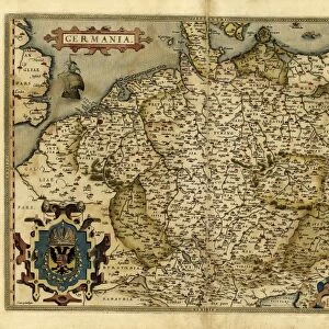
Map of Germany, from Theatrum Orbis Terrarum by Abraham Ortelius, 1528-1598, Antwerp, 1570

Filename: 940_18_11384385.jpg
Size: 5275 x 4095 (9.6MB)
Date: 16th March 2014
Source: Universal Images Group (UIG)
Source: De Agostini Picture Library
© DEA / A. DAGLI ORTI
![]()
Wall Art and Photo Gifts from Universal Images Group (UIG)
Map of Germany, from Theatrum Orbis Terrarum by Abraham Ortelius, 1528-1598, Antwerp, 1570
Cartography, 16th century. Map of Germany, from Theatrum Orbis Terrarum by Abraham Ortelius (1528-1598), Antwerp, 1570
Universal Images Group (UIG) manages distribution for many leading specialist agencies worldwide
Media ID 9572271
© DEA / A. DAGLI ORTI
16th Century Coat Of Arms Germany Latin Script Manuscript Sailing Boat
EDITORS COMMENTS
This print showcases a remarkable piece of cartographic history - the Map of Germany from Theatrum Orbis Terrarum by Abraham Ortelius. Created in Antwerp in 1570, this map is a true testament to the artistry and precision of 16th-century cartography. The intricate details on this map are truly awe-inspiring. Every city, river, and mountain range is meticulously depicted, offering a glimpse into the physical geography of Germany during that time period. The Latin script adds an air of authenticity to this masterpiece, reminding us of its historical significance. One cannot help but be drawn to the elegant coat of arms adorning the top left corner, symbolizing the rich heritage and power associated with Germany at that time. It serves as a reminder that maps were not merely navigational tools but also representations of political influence and territorial claims. Intriguingly, amidst all these geographical features lies a beautifully illustrated sailing boat - perhaps hinting at Germany's maritime prowess during the 16th century or simply adding an artistic touch to an already mesmerizing composition. As we gaze upon this extraordinary artwork, devoid of any human presence yet brimming with historical narrative, we are transported back in time. We can almost imagine explorers using similar maps to navigate uncharted territories or scholars poring over them for their wealth of knowledge. This print captures not only a stunning work of art but also invites us to delve into centuries-old stories etched onto paper – tales waiting
MADE IN THE USA
Safe Shipping with 30 Day Money Back Guarantee
FREE PERSONALISATION*
We are proud to offer a range of customisation features including Personalised Captions, Color Filters and Picture Zoom Tools
SECURE PAYMENTS
We happily accept a wide range of payment options so you can pay for the things you need in the way that is most convenient for you
* Options may vary by product and licensing agreement. Zoomed Pictures can be adjusted in the Cart.