Home > Arts > Artists > O > Abraham Ortelius
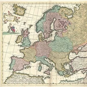
Orteliuss map of Europe, 1603

![]()
Wall Art and Photo Gifts from Science Photo Library
Orteliuss map of Europe, 1603
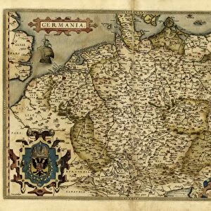
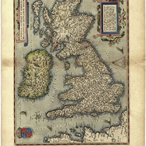
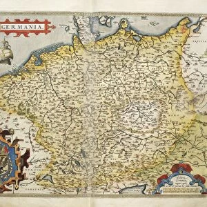
Orteliuss map of Europe. This map of Europe is from the 1603 edition of Theatrum orbis terrarum (Theatre of the World). First published in 1570 by Flemish mapmaker Abraham Ortelius (1527-1598), this collection of 53 maps is considered to be the first true modern atlas. There were two versions of the Europae map: 1570 and 1584. This is the 1603 state of the 1584 version (several states were produced between 1584 and 1609). It includes a compass rose (top right), a scale bar (lower left), and for the title there is a representation of the figure of Europa and the bull (upper left) from Greek mythology, personifying the continent
Science Photo Library features Science and Medical images including photos and illustrations
Media ID 9209757
© MIDDLE TEMPLE LIBRARY/SCIENCE PHOTO LIBRARY
1500s 1584 1600s 16th Century 17th Century Abraham Ortelius Age Of Discovery Baltic Sea Black Sea Bull Cartography Compass Rose Continent Continental Denmark Dutch Europa Flemish France Germany Holland Holy Roman Empire Iceland Ireland Italy Mediterranean Mythological Mythology Netherlands North Africa North Sea Norway Persia Russia Scale Bar Scotland Spain State Sweden Theatre Of The World Theatrum Orbis Terrarum 1603 Austro Hungarian Monarchy Lithuania Low Countries Spanish Empire Tartar
FEATURES IN THESE COLLECTIONS
> Africa
> Related Images
> Animals
> Insects
> Hemiptera
> Black Scale
> Animals
> Insects
> Hemiptera
> Rose Scale
> Arts
> Artists
> O
> Abraham Ortelius
> Arts
> Artists
> R
> Roman Roman
> Europe
> Denmark
> Related Images
> Maps and Charts
> Abraham Ortelius
EDITORS COMMENTS
This print showcases Orteliuss map of Europe from the 1603 edition of Theatrum orbis terrarum, known as the Theatre of the World. Crafted by Flemish mapmaker Abraham Ortelius in 1570, this collection of 53 maps is hailed as the first true modern atlas. The featured map is a state from the 1584 version, with several states produced between then and 1609. The intricate details on this historical artifact are truly remarkable. In addition to accurately depicting European geography during the 16th century, it includes various elements such as a compass rose at the top right corner and a scale bar at the lower left corner for measurement reference. Notably, its title features an artistic representation of Europa and the bull from Greek mythology—a symbolic personification of our beloved continent. As we delve into this mesmerizing artwork, we can explore countries like Italy, Russia, Ireland, Germany, Sweden, Denmark—each intricately illustrated with their own unique characteristics. From North Africa to Iceland and Norway to Spain—the entire European landscape unfolds before our eyes. This photograph not only captures an important piece of cartography but also offers us a glimpse into history—an era marked by exploration and discovery. It serves as a testament to Ortelius's pioneering work that laid down foundations for future generations' understanding of our ever-evolving world.
MADE IN THE USA
Safe Shipping with 30 Day Money Back Guarantee
FREE PERSONALISATION*
We are proud to offer a range of customisation features including Personalised Captions, Color Filters and Picture Zoom Tools
SECURE PAYMENTS
We happily accept a wide range of payment options so you can pay for the things you need in the way that is most convenient for you
* Options may vary by product and licensing agreement. Zoomed Pictures can be adjusted in the Cart.