Rights Managed > Universal Images Group (UIG) > Universal Images Group > Satellite and Aerial > Planet Observer 4
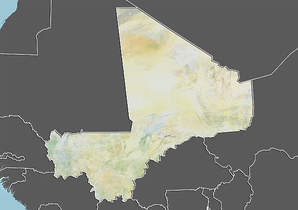
Mali, Relief Map With Border and Mask
Filename: 913_03_po03688.jpg
Size: 4961 x 3511 (1.9MB)
Date: 1st March 2012
Source: Universal Images Group (UIG)
© Planet Observer/UIG
![]()

Wall Art and Photo Gifts from Universal Images Group (UIG)
Mali, Relief Map With Border and Mask
Relief map of Mali (with border and mask). This image was compiled from data acquired by landsat 5 & 7 satellites combined with elevation data
Universal Images Group (UIG) manages distribution for many leading specialist agencies worldwide
Media ID 9613001
© Planet Observer/UIG
Africa Desert Mali Relief Map Sahara Bamako Niger River Satellite View Senegal River Tombouctou
EDITORS COMMENTS
This print showcases the intricate details of Mali's relief map, complete with a border and mask. Compiled from data acquired by Landsat 5 & 7 satellites combined with elevation data, this image offers a stunning visual representation of the country's diverse topography. The vast Sahara Desert dominates much of the landscape, its golden dunes stretching endlessly into the horizon. As we explore further, our eyes are drawn to the contrasting shades that depict varying elevations across Mali. The ancient city of Tombouctou stands out prominently on this map, reminding us of its rich historical significance as a center for trade and Islamic scholarship. The Senegal River gracefully winds its way through the western part of Mali, while the Niger River carves a path through its heartland. These lifelines have not only shaped Mali's physical geography but also played an essential role in sustaining life throughout history. Bamako, Mali's bustling capital city, is captured in vibrant color at one corner of this image—its urban sprawl juxtaposed against nature's raw beauty. This horizontal composition allows us to appreciate every detail meticulously captured by satellite view technology. As we delve into this photograph devoid of human presence, it serves as a reminder that nature reigns supreme in shaping our world. With cartographic precision and artistic flair, Universal Images Group (UIG) has immortalized Mali's breathtaking landscapes for all to admire—a testament to both scientific advancement and aesthetic appreciation.
MADE IN THE USA
Safe Shipping with 30 Day Money Back Guarantee
FREE PERSONALISATION*
We are proud to offer a range of customisation features including Personalised Captions, Color Filters and Picture Zoom Tools
SECURE PAYMENTS
We happily accept a wide range of payment options so you can pay for the things you need in the way that is most convenient for you
* Options may vary by product and licensing agreement. Zoomed Pictures can be adjusted in the Cart.


