Rights Managed > Universal Images Group (UIG) > Universal Images Group > Satellite and Aerial > Planet Observer 4
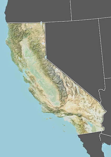
State of California, United States, Relief Map
Filename: 913_03_po04321.jpg
Size: 3511 x 4961 (2.8MB)
Date: 27th March 2012
Source: Universal Images Group (UIG)
© Planet Observer/UIG
![]()

Wall Art and Photo Gifts from Universal Images Group (UIG)
State of California, United States, Relief Map
Relief map of the State of California, United States. This image was compiled from data acquired by LANDSAT 5 & 7 satellites combined with elevation data
Universal Images Group (UIG) manages distribution for many leading specialist agencies worldwide
Media ID 9618955
© Planet Observer/UIG
California Coastline Desert Los Angeles Mountain Relief Map San Diego San Francisco Shore State Sacramento San Andreas Fault Satellite View Sierra Nevada
EDITORS COMMENTS
This print showcases the stunning relief map of the State of California, United States. Compiled from data acquired by LANDSAT 5 & 7 satellites combined with elevation data, this image offers a unique perspective on California's diverse topography. From majestic mountains to sprawling deserts, and from bustling cities like Los Angeles and San Francisco to picturesque shorelines, this map encapsulates the essence of California's physical geography. The vertical composition allows viewers to appreciate the vastness and grandeur of this state in North America. The intricate details captured in this satellite view highlight key landmarks such as Sacramento, San Diego, and even the infamous San Andreas Fault. The color image brings life to every contour and feature on display. With no people present in the frame, one can fully immerse themselves in exploring California's natural beauty through cartography. The Sierra Nevada mountain range dominates much of the landscape while coastal regions offer a striking contrast between land and sea. Whether you are an avid traveler or simply fascinated by maps, this print is sure to captivate your imagination as it invites you into an exploration of California's remarkable terrain. It serves as a testament to both human ingenuity in compiling such detailed information and nature's awe-inspiring creations found within this beloved state.
MADE IN THE USA
Safe Shipping with 30 Day Money Back Guarantee
FREE PERSONALISATION*
We are proud to offer a range of customisation features including Personalised Captions, Color Filters and Picture Zoom Tools
SECURE PAYMENTS
We happily accept a wide range of payment options so you can pay for the things you need in the way that is most convenient for you
* Options may vary by product and licensing agreement. Zoomed Pictures can be adjusted in the Cart.

