
Rights Managed > Universal Images Group (UIG) > Universal Images Group > Satellite and Aerial > Planet Observer 6
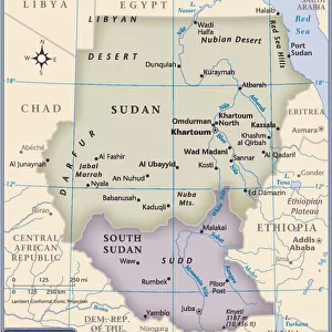
Sudan, Relief Map

Sudan, Relief Map


Please Click On A License Option

Filename: 913_03_PO05848.jpg

Size: 4961 x 3511 (2.1MB)

Date: 11th September 2012

Source: Universal Images Group (UIG)

© Planet Observer

We accept all major credit cards


Image Downloads
Framed Photos
Photo Prints
Jigsaw Puzzles
Poster Prints
Canvas Prints
Fine Art Prints
Metal Prints
Home Decor


UIG

Wall Art and Photo Gifts from Universal Images Group (UIG)

Sudan, Relief Map

Relief map of Sudan. This map was processed from elevation data

Universal Images Group (UIG) manages distribution for many leading specialist agencies worldwide

Media ID 9615513

© Planet Observer

Alsace Bas Rhin Geographical Border Relief Map Satellite View


MADE IN THE USA
Safe Shipping with 30 Day Money Back Guarantee

FREE PERSONALISATION*
We are proud to offer a range of customisation features including Personalised Captions, Color Filters and Picture Zoom Tools

SECURE PAYMENTS
We happily accept a wide range of payment options so you can pay for the things you need in the way that is most convenient for you

* Options may vary by product and licensing agreement. Zoomed Pictures can be adjusted in the Cart.

lightbox add My Lightbox


Related Images


Map Of Egypt, Sudan, 1899
Map of Sudan, late 19th Century
Antique map of Middle East with Arabia, Egypt, Nubia, and Abyssinia
Mahdist War, Map of the rebellion in Sudan, 1884
Map Showing The Battle Of Atbara During The Second Sudan War Also Called The Mahdist War, The Mahdist Revolt, Anglo-Sudan War Or The Sudanese Mahdist Revolt, 1898. From Field Marshal Lord Kitchener, His Life And Work For The Empire, Published 1916
Map Of The Battle Of Omdurman, Khartoum, Sudan, 1898, Showing The 1st Attack At 6. 45 A. m. And The Khalifas Attack At 9. 40 A. m. From Field Marshal Lord Kitchener, His Life And Work For The Empire, Published 1916
Kartoum Sudan In 1884 Drawn From Rough Sketches Made By General Gordon From The Journals Of Major-Gen. C. G. Gordon C. B. At Kartoum Published By Kegan Paul Trench & Co London 1885
Sudan country map
Sudan country map
Telegraph map of Upper Egypt
Map of the war in North Africa by G. H. Davis
Map Egypt and Sudan
Map Egypt and Sudan
1818, Pinkerton Map of Nubia, Sudan and Abyssinia, John Pinkerton, 1758 - 1826, Scottish