Home > Abstract Art > Painting > Related Images
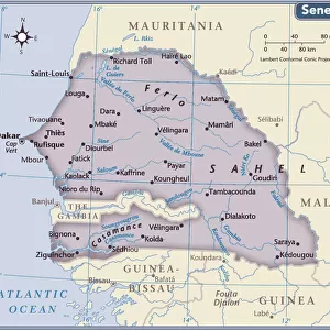
West Guinea, containing the Capo Verde Islands and Senegal, the coast properly called Guinea, engraving by G. Zuliani taken from Tome IV of the "Newest Atlas" published in Venice in 1784 by Antonio Zatta, Private Collection

![]()
Wall Art and Photo Gifts from Fondazione Alinari per la Fotografia
West Guinea, containing the Capo Verde Islands and Senegal, the coast properly called Guinea, engraving by G. Zuliani taken from Tome IV of the "Newest Atlas" published in Venice in 1784 by Antonio Zatta, Private Collection
West Guinea, containing the Capo Verde Islands and Senegal, the coast properly called Guinea, engraving by G. Zuliani taken from Tome IV of the "Newest Atlas" published in Venice in 1784 by Antonio Zatta, Private Collection Florence Engraving Eighteenth Century, Renaissance-Baroque styles and periods, Europe, First and Second Millennium A.D.. Date of Photograph:2009. Date of Artwork:1784. Artist:Zuliani G
Alinari
PDP-A-ZATTA4-0017
Media ID 33187625
© Alinari Archives, Florence
Cartography Drawing And Graphics Geographical Or Topographical Map Geography Graphics Instrument And Document Islandeighteenth Century Scene Means Of Communication Territory Abstract Concept And Symbol Concept Or Subject Expressed
FEATURES IN THESE COLLECTIONS
> Abstract Art
> Painting
> Related Images
> Abstract Art
> Water
> Africa
> Senegal
> Related Images
> Arts
> Abstract art
> Arts
> Art Movements
> Baroque
> Arts
> Art Movements
> Renaissance Art
> Arts
> Still life artwork
> Abstract art
> Fine art
> Arts
> Minimalist artwork
> Abstract art
> Fine art
EDITORS COMMENTS
This print showcases an exquisite engraving by G. Zuliani, taken from Tome IV of the "Newest Atlas" published in Venice in 1784 by Antonio Zatta. The artwork is part of a private collection and depicts West Guinea, including the Capo Verde Islands and Senegal, with the coast properly known as Guinea. The intricate details of this Renaissance-Baroque style engraving transport us back to the eighteenth century, offering a glimpse into Europe's cartographic history. It serves as a testament to the remarkable craftsmanship and artistry prevalent during that time period. As we delve into this piece, we are struck by its allegorical nature. Through its abstract concepts and symbols, it conveys not only geographical information but also deeper meanings associated with territory and communication. This map becomes more than just lines on paper; it becomes a gateway to understanding the world through visual representation. The presence of sea and islands adds depth to this composition, evoking a sense of exploration and adventure that characterized European voyages during this era. It reminds us of how maps were not merely practical tools but also works of art that ignited curiosity about distant lands. Photographed in 2009 but originally created in 1784, this artwork by Zuliani G stands as an enduring testament to human ingenuity across centuries. Its preservation within Florence's private collection speaks volumes about its historical significance. Through Alinari's lens capturing every intricate detail, we are transported back in time—a journey that allows us to appreciate both the technical skill involved in creating such engravings and their lasting impact on our understanding of geography and culture throughout history.
MADE IN THE USA
Safe Shipping with 30 Day Money Back Guarantee
FREE PERSONALISATION*
We are proud to offer a range of customisation features including Personalised Captions, Color Filters and Picture Zoom Tools
SECURE PAYMENTS
We happily accept a wide range of payment options so you can pay for the things you need in the way that is most convenient for you
* Options may vary by product and licensing agreement. Zoomed Pictures can be adjusted in the Cart.