Canvas Print > Maps and Charts > World
Canvas Print : Central Europe, 1914-1920 (colour litho)
")

")


![]()
Canvas Prints from Fine Art Finder
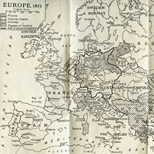
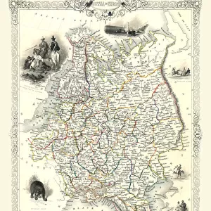
Central Europe, 1914-1920 (colour litho)
6008534 Central Europe, 1914-1920 (colour litho) by English School, (20th century); Private Collection; (add.info.: Central Europe, 1914-1920. Illustration for Harmsworths Atlas of the World and Pictorial Gazetteer edited by J A Hamerton (Amalgamated Press, c 1921).); © Look and Learn
Media ID 22332800
© Look and Learn / Bridgeman Images
1921 Atlas Central Europe Post Ww1 1920s 20s 20s Mythological Figure Pagan Paganism Pagans Polytheism Polytheist
20"x16" (51x41cm) Canvas Print
Bring the rich history of Central Europe to life in your home with Media Storehouse's Canvas Prints. This stunning, color lithograph by the English School depicts Central Europe during the tumultuous years of 1914-1920. With intricate details and vibrant hues, this fine art print transports you back in time. The high-quality canvas material adds depth and texture, making it a beautiful and unique addition to any room. Discover the story behind this captivating piece from Bridgeman Images through Fine Art Finder and let Media Storehouse help you bring it into your personal collection.
Delivered stretched and ready to hang our premium quality canvas prints are made from a polyester/cotton blend canvas and stretched over a 1.25" (32mm) kiln dried knot free wood stretcher bar. Packaged in a plastic bag and secured to a cardboard insert for safe transit.
Canvas Prints add colour, depth and texture to any space. Professionally Stretched Canvas over a hidden Wooden Box Frame and Ready to Hang
Estimated Product Size is 50.8cm x 40.6cm (20" x 16")
These are individually made so all sizes are approximate
Artwork printed orientated as per the preview above, with landscape (horizontal) orientation to match the source image.
FEATURES IN THESE COLLECTIONS
> Maps and Charts
> Early Maps
> Maps and Charts
> Related Images
> Maps and Charts
> World
> Popular Themes
> Religious Images
> Fine Art Finder
> Artists
> English Photographer
> Fine Art Finder
> Artists
> English School
Central Europe, 1914-1920 - A Glimpse into a Transformative Era
EDITORS COMMENTS
. This print titled "Central Europe, 1914-1920" offers a vivid portrayal of the region during a tumultuous period in history. Created by an anonymous English School artist in the early 20th century, this colour lithograph was featured in Harmsworths Atlas of the World and Pictorial Gazetteer edited by J. A. Hamerton. The image transports us back to a time when Central Europe was undergoing significant changes following the devastation of World War I. The map-like composition showcases various mythological figures and characters intertwined with symbols representing different religious beliefs and pagan traditions. This juxtaposition highlights the complex tapestry of cultures and ideologies that shaped Central Europe during this era. As we explore this artwork further, it becomes evident that it serves as more than just a geographical representation; it is also an exploration of mythology, religion, and historical context. It invites viewers to reflect on how these elements influenced society's collective consciousness at that time. With its vibrant colors and intricate details, this print captures both the chaos and resilience witnessed throughout Central Europe between 1914-1920. It stands as a testament to humanity's ability to adapt amidst adversity while reminding us of our shared past. Displayed here courtesy of Bridgeman Images' Fine Art Finder collection, this piece provides valuable insight into an important chapter in European history—a visual reminder for future generations about the transformative power
MADE IN THE USA
Safe Shipping with 30 Day Money Back Guarantee
FREE PERSONALISATION*
We are proud to offer a range of customisation features including Personalised Captions, Color Filters and Picture Zoom Tools
SECURE PAYMENTS
We happily accept a wide range of payment options so you can pay for the things you need in the way that is most convenient for you
* Options may vary by product and licensing agreement. Zoomed Pictures can be adjusted in the Cart.