Canvas Print > Arts > Artists > M > Gerardus Mercator
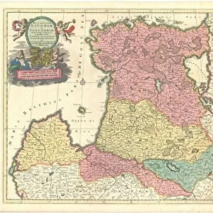
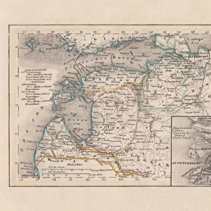
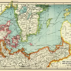
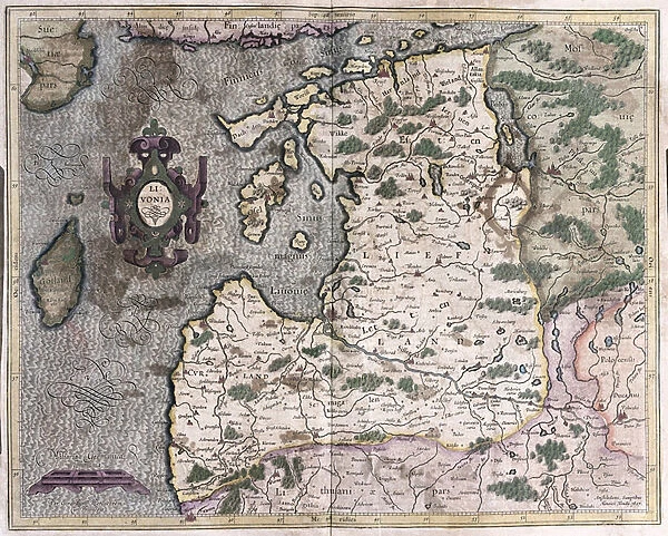
Canvas Print : Northern Baltic region, Riga, Latvia (engraving, 1596)
")
")

![]()
Canvas Prints from Fine Art Finder
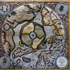
Northern Baltic region, Riga, Latvia (engraving, 1596)
LRI4716949 Northern Baltic region, Riga, Latvia (engraving, 1596) by Mercator, Gerardus (1512-94); Private Collection; (add.info.: Livonia, 1633: Northern Baltic region, Riga, Latvia - in " Atlas Ssive Corsmographicae Meditationes" by Gerard Mercator (Gerard de Kremer - Gerhard Kremer - Gerardus Mercator) (1512-1594), Duisburg 1596); Luisa Ricciarini; Flemish, out of copyright
Media ID 23327806
© Luisa Ricciarini / Bridgeman Images
Atlas Book Baltic Countries Geographical Map
20"x16" (51x41cm) Canvas Print
Bring the historical charm of the Northern Baltic region to your home with our exquisite Canvas Print of Riga, Latvia, as depicted in an engraving from 1596 by Gerardus Mercator. This stunning artwork, captured by Luisa Ricciarini from Fine Art Finder, showcases the beauty and rich history of Riga during the Livonian era. Each Canvas Print is meticulously crafted with premium materials and vibrant colors, ensuring a museum-quality finish that will elevate any space. Transport yourself back in time with this captivating piece of art.
Delivered stretched and ready to hang our premium quality canvas prints are made from a polyester/cotton blend canvas and stretched over a 1.25" (32mm) kiln dried knot free wood stretcher bar. Packaged in a plastic bag and secured to a cardboard insert for safe transit.
Canvas Prints add colour, depth and texture to any space. Professionally Stretched Canvas over a hidden Wooden Box Frame and Ready to Hang
Estimated Product Size is 50.8cm x 40.6cm (20" x 16")
These are individually made so all sizes are approximate
Artwork printed orientated as per the preview above, with landscape (horizontal) orientation to match the source image.
FEATURES IN THESE COLLECTIONS
> Arts
> Artists
> M
> Gerardus Mercator
> Europe
> Latvia
> Related Images
> Maps and Charts
> Gerardus Mercator's Cartographic
> Maps and Charts
> Related Images
> Fine Art Finder
> Artists
> Gerardus Mercator
> Fine Art Finder
> Artists
> Jose Guadalupe Posada
EDITORS COMMENTS
This print showcases an exquisite engraving from 1596, depicting the Northern Baltic region in Riga, Latvia. Created by the renowned cartographer Gerardus Mercator (1512-94), this masterpiece is a true testament to his exceptional talent and attention to detail. The engraving, part of the "Atlas Ssive Corsmographicae Meditationes" offers a fascinating glimpse into the geographical landscape of Livonia during that era. With its intricate lines and delicate craftsmanship, it transports us back in time to explore this historical region. Luisa Ricciarini has skillfully captured this remarkable artwork through her lens, preserving its beauty for generations to come. The richness of colors and textures in this print truly brings out the essence of Mercator's original creation. As we admire this image, we are reminded of the significance of maps as windows into our past. They not only serve as navigational tools but also provide valuable insights into the cultural and political landscapes of different periods. Whether you are a history enthusiast or simply appreciate fine art, this enchanting print is sure to captivate your imagination. Let yourself be transported back in time as you explore the Northern Baltic region through Mercator's eyes and experience a slice of Latvia's rich heritage.
MADE IN THE USA
Safe Shipping with 30 Day Money Back Guarantee
FREE PERSONALISATION*
We are proud to offer a range of customisation features including Personalised Captions, Color Filters and Picture Zoom Tools
SECURE PAYMENTS
We happily accept a wide range of payment options so you can pay for the things you need in the way that is most convenient for you
* Options may vary by product and licensing agreement. Zoomed Pictures can be adjusted in the Cart.