Canvas Print > Asia > India > Maps
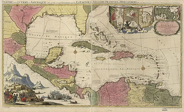
Canvas Print : Theatre or War, Mexican Archipelago - the Caribbean, 1757


![]()
Canvas Prints from Fine Art Finder
Theatre or War, Mexican Archipelago - the Caribbean, 1757
2902869 Theatre or War, Mexican Archipelago - the Caribbean, 1757; (add.info.: Theatre or War, Mexican Archipelago - the Caribbean, 1757.); Buyenlarge Archive/UIG
Media ID 38316736
© Buyenlarge Archive/UIG / Bridgeman Images
1750s Bahamas Caribbean Caribbean Island Cartographic Hispaniola Indies Islands Jamaica Puerto Rico Virgin Islands
30"x20" (76x51cm) Canvas Print
Transport yourself back in time with this stunning canvas print of "Theatre or War, Mexican Archipelago - the Caribbean, 1757" by Bridgeman Images. A captivating piece that will add a touch of history to any space.
Delivered stretched and ready to hang our premium quality canvas prints are made from a polyester/cotton blend canvas and stretched over a 1.25" (32mm) kiln dried knot free wood stretcher bar. Packaged in a plastic bag and secured to a cardboard insert for safe transit.
Canvas Prints add colour, depth and texture to any space. Professionally Stretched Canvas over a hidden Wooden Box Frame and Ready to Hang
Estimated Product Size is 76.2cm x 50.8cm (30" x 20")
These are individually made so all sizes are approximate
Artwork printed orientated as per the preview above, with landscape (horizontal) orientation to match the source image.
FEATURES IN THESE COLLECTIONS
> Asia
> India
> Related Images
> Maps and Charts
> India
> North America
> The Bahamas
> Maps
> North America
> The Bahamas
> Related Images
> North America
> Jamaica
> Maps
> North America
> Jamaica
> Related Images
> North America
> Mexico
> Maps
> North America
> Mexico
> Related Images
> Fine Art Finder
> Artists
> Noel Rooke
EDITORS COMMENTS
This print captures the intricate cartography of the Mexican Archipelago in the Caribbean during the year 1757. The detailed map showcases various islands such as Jamaica, Puerto Rico, Hispaniola, and the Virgin Islands, providing a glimpse into the strategic importance of these territories during times of war.
The vibrant colors and precise detailing of this historical map transport viewers back to a time when naval battles and territorial disputes shaped the course of history in North America. The careful craftsmanship involved in creating such maps is evident in every line and symbol, reflecting both scientific accuracy and artistic flair.
As we gaze upon this piece, we are reminded of the complex geopolitical landscape that defined this era, with European powers vying for control over lucrative trade routes and valuable resources. The sheer size and scope of this map serve as a testament to human ingenuity and exploration, showcasing our relentless quest for knowledge and power.
Whether you are a history buff or simply appreciate fine artistry, this print is sure to captivate your imagination and spark curiosity about the fascinating world of cartography. Let yourself be transported to a bygone era where land was conquered through maps as much as through swords.
MADE IN THE USA
Safe Shipping with 30 Day Money Back Guarantee
FREE PERSONALISATION*
We are proud to offer a range of customisation features including Personalised Captions, Color Filters and Picture Zoom Tools
SECURE PAYMENTS
We happily accept a wide range of payment options so you can pay for the things you need in the way that is most convenient for you
* Options may vary by product and licensing agreement. Zoomed Pictures can be adjusted in the Cart.