Canvas Print > Europe > Italy > Lazio > Rome
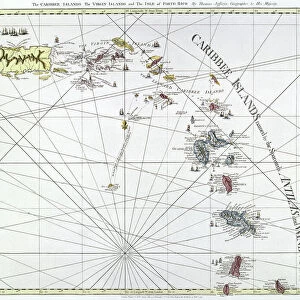
Canvas Print : Geography map: representation of the island of Hispaniola (Santo Domingo and Haiti) (Greater Antilles), of the Virgin Islands (Lesser Antilles) in Central America from an Atlas made by the Italian cartographer Antonio Francesco Lucini (born 1605)
 (Greater Antilles), of the Virgin Islands (Lesser Antilles) in Central America from an Atlas made by the Italian cartographer Antonio Francesco Lucini (born 1605)")
 (Greater Antilles), of the Virgin Islands (Lesser Antilles) in Central America from an Atlas made by the Italian cartographer Antonio Francesco Lucini (born 1605)")


![]()
Canvas Prints from Fine Art Finder
Geography map: representation of the island of Hispaniola (Santo Domingo and Haiti) (Greater Antilles), of the Virgin Islands (Lesser Antilles) in Central America from an Atlas made by the Italian cartographer Antonio Francesco Lucini (born 1605)
VEN5030472 Geography map: representation of the island of Hispaniola (Santo Domingo and Haiti) (Greater Antilles), of the Virgin Islands (Lesser Antilles) in Central America from an Atlas made by the Italian cartographer Antonio Francesco Lucini (born 1605), about 1661 Biblioteca Angelica, Rome; (add.info.: Geography map: representation of the island of Hispaniola (Santo Domingo and Haiti) (Greater Antilles), of the Virgin Islands (Lesser Antilles) in Central America from an Atlas made by the Italian cartographer Antonio Francesco Lucini (born 1605), about 1661 Biblioteca Angelica, Rome); © Marage Photos
Media ID 38484914
© © Marage Photos / Bridgeman Images
17eme Siecle Amerique Centrale Amerique Du Nord Caribbean Carte Geographique Central America Etats Unis Geographie Haiti Stockravenna 17th Centuries Etats Unis Etats Unis Usa United States Geographical Map
30"x20" (76x51cm) Canvas Print
Explore the rich history and intricate details of Central America with this stunning canvas print featuring a geography map by Italian cartographer Antonio Francesco Lucini. Perfect for adding a touch of sophistication to any space.
Delivered stretched and ready to hang our premium quality canvas prints are made from a polyester/cotton blend canvas and stretched over a 1.25" (32mm) kiln dried knot free wood stretcher bar. Packaged in a plastic bag and secured to a cardboard insert for safe transit.
Canvas Prints add colour, depth and texture to any space. Professionally Stretched Canvas over a hidden Wooden Box Frame and Ready to Hang
Estimated Product Size is 76.2cm x 50.8cm (30" x 20")
These are individually made so all sizes are approximate
Artwork printed orientated as per the preview above, with landscape (horizontal) orientation to match the source image.
FEATURES IN THESE COLLECTIONS
> Europe
> Italy
> Lazio
> Rome
> Maps and Charts
> Early Maps
> Maps and Charts
> Italy
> Maps and Charts
> Related Images
> North America
> Haiti
> Maps
> North America
> Haiti
> Related Images
> North America
> United States of America
> Maps
> North America
> US Virgin Islands
> Maps
> Fine Art Finder
> Artists
> Pasquier (workshop of) Grenier
EDITORS COMMENTS
This stunning print captures a detailed geography map of the island of Hispaniola (Santo Domingo and Haiti) in the Greater Antilles, as well as the Virgin Islands in the Lesser Antilles. Created by Italian cartographer Antonio Francesco Lucini around 1661, this piece is a true testament to the artistry and precision of mapmaking during the 17th century.
The intricate details on this map showcase not only geographical features but also historical significance, offering a glimpse into the past of Central America. The careful handiwork of Lucini is evident in every line and symbol, highlighting his expertise in cartography.
As you study this image closely, you can almost feel yourself being transported back in time to an era where exploration and discovery were at their peak. The rich history embedded within this map tells a story of colonization, trade routes, and cultural exchange that shaped the region for centuries to come.
Displayed in Biblioteca Angelica in Rome, this atlas serves as a valuable resource for understanding the complexities of early American geography. It stands as a reminder of how maps have not only guided travelers but also served as works of art that capture our world's beauty and diversity.
MADE IN THE USA
Safe Shipping with 30 Day Money Back Guarantee
FREE PERSONALISATION*
We are proud to offer a range of customisation features including Personalised Captions, Color Filters and Picture Zoom Tools
SECURE PAYMENTS
We happily accept a wide range of payment options so you can pay for the things you need in the way that is most convenient for you
* Options may vary by product and licensing agreement. Zoomed Pictures can be adjusted in the Cart.