Canvas Print > Europe > Italy > Sicily > Messina
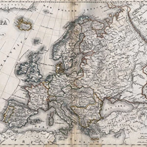
Canvas Print : Map of Europe and coasts of the North of Africa, 1587


![]()
Canvas Prints from Fine Art Finder
Map of Europe and coasts of the North of Africa, 1587
3499620 Map of Europe and coasts of the North of Africa, 1587 by Martines, Joan (16th century); (add.info.: Map of Europe and coasts of the North of Africa. Nautical letter (Portulan) by Joan Martines. Messina, Sicily, 1587.); PHAS/UIG; Spanish, out of copyright
Media ID 22442230
© PHAS/UIG / Bridgeman Images
Coasts Joan Messina Nautical North Sicily Martines Portulan
20"x16" (51x41cm) Canvas Print
Add a touch of historical charm to your home or office with our Canvas Print of the intricately detailed Map of Europe and the coasts of North Africa, dating back to 1587. This stunning artwork, captured by Bridgeman Images from Fine Art Finder, features the meticulous cartography of Joan Martines. The vintage map design transports you back in time, making it an excellent conversation starter and a unique decor piece. Order now and bring history into your space.
Delivered stretched and ready to hang our premium quality canvas prints are made from a polyester/cotton blend canvas and stretched over a 1.25" (32mm) kiln dried knot free wood stretcher bar. Packaged in a plastic bag and secured to a cardboard insert for safe transit.
Canvas Prints add colour, depth and texture to any space. Professionally Stretched Canvas over a hidden Wooden Box Frame and Ready to Hang
Estimated Product Size is 40.6cm x 50.8cm (16" x 20")
These are individually made so all sizes are approximate
Artwork printed orientated as per the preview above, with portrait (vertical) orientation to match the source image.
FEATURES IN THESE COLLECTIONS
> Europe
> Italy
> Sicily
> Messina
> Europe
> Italy
> Sicily
> Related Images
> Maps and Charts
> Related Images
> Maps and Charts
> Spain
> Fine Art Finder
> Artists
> Joan Martines
> Fine Art Finder
> Artists
> Spanish School (after)
EDITORS COMMENTS
This print showcases a remarkable piece of cartographic history - the "Map of Europe and coasts of the North of Africa, 1587" by Joan Martines. Created in Messina, Sicily during the 16th century, this nautical letter (Portulan) offers a fascinating glimpse into the geographical knowledge and navigational techniques of that era. The intricate details depicted on this map transport us back to a time when exploration and discovery were at their peak. With its meticulously drawn coastlines, cities, and landmarks, it serves as an invaluable record of how Europeans perceived their world centuries ago. The inclusion of North African coasts adds another layer to its significance, highlighting the interconnectedness between these regions during that period. As we study this ancient artifact through modern eyes, we can't help but marvel at Martines' skillful craftsmanship and attention to detail. Every stroke seems purposeful; every contour carefully considered. It is evident that this map was not only intended for practical use but also served as a work of art in its own right. Thanks to Bridgeman Images' preservation efforts, we are fortunate enough to have access to such historical treasures like this one. This print allows us to appreciate Martines' masterpiece from afar while reminding us of our shared human curiosity for exploration and understanding.
MADE IN THE USA
Safe Shipping with 30 Day Money Back Guarantee
FREE PERSONALISATION*
We are proud to offer a range of customisation features including Personalised Captions, Color Filters and Picture Zoom Tools
SECURE PAYMENTS
We happily accept a wide range of payment options so you can pay for the things you need in the way that is most convenient for you
* Options may vary by product and licensing agreement. Zoomed Pictures can be adjusted in the Cart.