Canvas Print > Europe > United Kingdom > Wales > Railways
Canvas Print : Map of proposed railway lines to run through Britain


![]()
Canvas Prints from Fine Art Finder
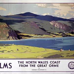
Map of proposed railway lines to run through Britain
3733987 Map of proposed railway lines to run through Britain.; (add.info.: Map of proposed railway lines to run through Britain. Dated 19th century.); Universal History Archive/UIG
Media ID 38447036
© Universal History Archive/UIG / Bridgeman Images
British Railway Rail Railroads Trains Welsh Connectivity
20"x16" (51x41cm) Canvas Print
Explore the rich history of Britain's railway development with this captivating canvas print featuring a detailed map of proposed railway lines. Perfect for adding a touch of vintage charm to your home decor.
Delivered stretched and ready to hang our premium quality canvas prints are made from a polyester/cotton blend canvas and stretched over a 1.25" (32mm) kiln dried knot free wood stretcher bar. Packaged in a plastic bag and secured to a cardboard insert for safe transit.
Canvas Prints add colour, depth and texture to any space. Professionally Stretched Canvas over a hidden Wooden Box Frame and Ready to Hang
Estimated Product Size is 40.6cm x 50.8cm (16" x 20")
These are individually made so all sizes are approximate
Artwork printed orientated as per the preview above, with portrait (vertical) orientation to match the source image.
FEATURES IN THESE COLLECTIONS
> Europe
> United Kingdom
> England
> Maps
> Europe
> United Kingdom
> England
> Railways
> Europe
> United Kingdom
> Maps
> Europe
> United Kingdom
> Scotland
> Maps
> Europe
> United Kingdom
> Scotland
> Posters
> Europe
> United Kingdom
> Scotland
> Railways
> Europe
> United Kingdom
> Scotland
> Related Images
> Europe
> United Kingdom
> Wales
> Maps
> Europe
> United Kingdom
> Wales
> Posters
> Europe
> United Kingdom
> Wales
> Railways
> Fine Art Finder
> Artists
> Unknown photographer
EDITORS COMMENTS
This fascinating 19th century map showcases the proposed railway lines that were set to run through Britain, highlighting the ambitious plans for connectivity and transportation in the region. The intricate details of this Victorian-era rail network plan offer a glimpse into the vision and innovation of the time, as engineers sought to revolutionize travel across England, Scotland, and Wales.
As we study this historical document, we are reminded of the importance of railways in shaping modern society and facilitating economic growth. The development of these railroads played a crucial role in connecting communities, enabling faster movement of goods and people, and ultimately transforming Britain into an industrial powerhouse.
The map not only serves as a visual representation of past aspirations but also sparks curiosity about how these plans may have influenced the landscape we see today. It is a testament to human ingenuity and determination to overcome geographical barriers through innovative infrastructure projects.
Through this print from Bridgeman Images, we are transported back in time to an era where progress was measured by miles of track laid down rather than megabytes transferred. It is a reminder that even centuries ago, people were thinking ahead about how best to connect our world for mutual benefit.
MADE IN THE USA
Safe Shipping with 30 Day Money Back Guarantee
FREE PERSONALISATION*
We are proud to offer a range of customisation features including Personalised Captions, Color Filters and Picture Zoom Tools
SECURE PAYMENTS
We happily accept a wide range of payment options so you can pay for the things you need in the way that is most convenient for you
* Options may vary by product and licensing agreement. Zoomed Pictures can be adjusted in the Cart.