Metal Print > Europe > United Kingdom > Wales > Railways
Metal Print : Map of proposed railway lines to run through Britain


![]()
Metal Prints from Fine Art Finder
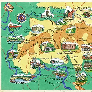
Map of proposed railway lines to run through Britain
3733987 Map of proposed railway lines to run through Britain.; (add.info.: Map of proposed railway lines to run through Britain. Dated 19th century.); Universal History Archive/UIG
Media ID 38447036
© Universal History Archive/UIG / Bridgeman Images
British Railway Rail Railroads Trains Welsh Connectivity
16"x20" (51x41cm) Metal Print
Step into the past with our Metal Prints from Media Storehouse! This stunning piece, 'Map of Proposed Railway Lines to Run Through Britain' by Bridgeman Images from Fine Art Finder, takes you on a journey through time and space. Dated back to the 19th century, this vintage map showcases proposed railway lines that would have connected Britain like never before. A unique addition to any room's decor, our Metal Prints are made with high-quality materials for a sleek and modern finish.
Made with durable metal and luxurious printing techniques, our metal photo prints go beyond traditional canvases, adding a cool, modern touch to your space. Wall mount on back. Eco-friendly 100% post-consumer recycled ChromaLuxe aluminum surface. The thickness of the print is 0.045". Featuring a Scratch-resistant surface and Rounded corners. Backing hangers are attached to the back of the print and float the print 1/2-inch off the wall when hung, the choice of hanger may vary depending on size and International orders will come with Float Mount hangers only. Finished with a brilliant white high gloss surface for unsurpassed detail and vibrance. Printed using Dye-Sublimation and for best care we recommend a non-ammonia glass cleaner, water, or isopropyl (rubbing) alcohol to prevent harming the print surface. We recommend using a clean, lint-free cloth to wipe off the print. The ultra-hard surface is scratch-resistant, waterproof and weatherproof. Avoid direct sunlight exposure.
Made with durable metal and luxurious printing techniques, metal prints bring images to life and add a modern touch to any space
Estimated Image Size (if not cropped) is 40.6cm x 50.8cm (16" x 20")
Estimated Product Size is 41.2cm x 51.4cm (16.2" x 20.2")
These are individually made so all sizes are approximate
Artwork printed orientated as per the preview above, with portrait (vertical) orientation to match the source image.
FEATURES IN THESE COLLECTIONS
> Fine Art Finder
> Artists
> Unknown photographer
> Europe
> United Kingdom
> England
> Maps
> Europe
> United Kingdom
> England
> Railways
> Europe
> United Kingdom
> Maps
> Europe
> United Kingdom
> Scotland
> Maps
> Europe
> United Kingdom
> Scotland
> Posters
> Europe
> United Kingdom
> Scotland
> Railways
> Europe
> United Kingdom
> Scotland
> Related Images
> Europe
> United Kingdom
> Wales
> Maps
> Europe
> United Kingdom
> Wales
> Posters
> Europe
> United Kingdom
> Wales
> Railways
EDITORS COMMENTS
This fascinating 19th century map showcases the proposed railway lines that were set to run through Britain, highlighting the ambitious plans for connectivity and transportation in the region. The intricate details of this Victorian-era rail network plan offer a glimpse into the vision and innovation of the time, as engineers sought to revolutionize travel across England, Scotland, and Wales.
As we study this historical document, we are reminded of the importance of railways in shaping modern society and facilitating economic growth. The development of these railroads played a crucial role in connecting communities, enabling faster movement of goods and people, and ultimately transforming Britain into an industrial powerhouse.
The map not only serves as a visual representation of past aspirations but also sparks curiosity about how these plans may have influenced the landscape we see today. It is a testament to human ingenuity and determination to overcome geographical barriers through innovative infrastructure projects.
Through this print from Bridgeman Images, we are transported back in time to an era where progress was measured by miles of track laid down rather than megabytes transferred. It is a reminder that even centuries ago, people were thinking ahead about how best to connect our world for mutual benefit.
MADE IN THE USA
Safe Shipping with 30 Day Money Back Guarantee
FREE PERSONALISATION*
We are proud to offer a range of customisation features including Personalised Captions, Color Filters and Picture Zoom Tools
SECURE PAYMENTS
We happily accept a wide range of payment options so you can pay for the things you need in the way that is most convenient for you
* Options may vary by product and licensing agreement. Zoomed Pictures can be adjusted in the Cart.