Canvas Print > Historic > Ancient civilizations > Ancient Greece > Greek history
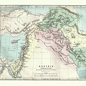
Canvas Print : Antique Map of the Assyrian Empire


![]()
Canvas Prints from Fine Art Storehouse
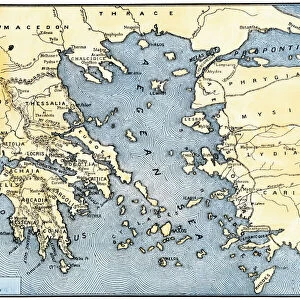
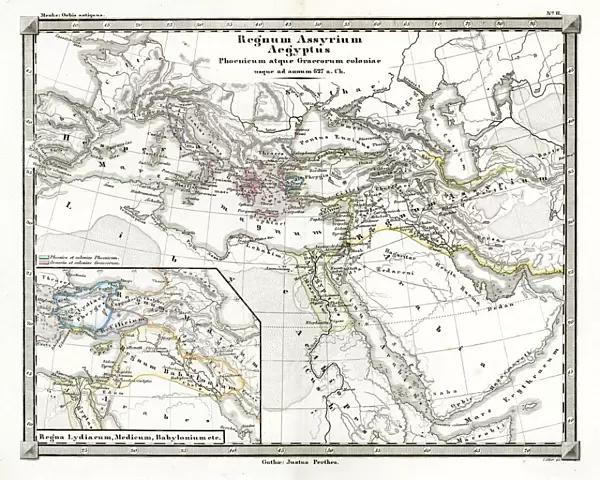
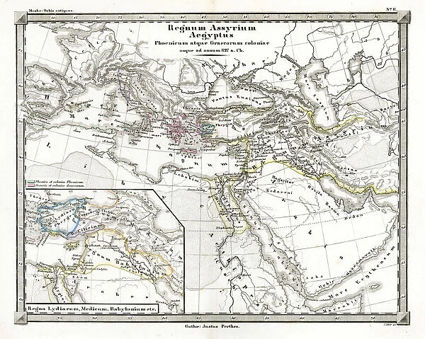
Antique Map of the Assyrian Empire
Antique Map from 1862 of Assyrian Empire also showing Phoenician and Greek colonies circa 627 BC. Maps text is written in Latin
Unleash your creativity and transform your space into a visual masterpiece!
duncan1890
Media ID 18062969
© Duncan Walker
20"x16" (51x41cm) Canvas Print
Step back in time with our exquisite Assyrian Empire Canvas Print from Media Storehouse. This stunning antique map, created in 1862, beautifully depicts the Assyrian Empire, along with Phoenician and Greek colonies, as they existed around 627 BC. The intricate details of this vintage map are brought to life in vibrant colors on a high-quality canvas, adding an air of sophistication and history to any room. The text is written in Latin, adding to the map's antique charm. Elevate your home decor with this unique and captivating piece from the Fine Art Storehouse collection at Media Storehouse.
Delivered stretched and ready to hang our premium quality canvas prints are made from a polyester/cotton blend canvas and stretched over a 1.25" (32mm) kiln dried knot free wood stretcher bar. Packaged in a plastic bag and secured to a cardboard insert for safe transit.
Canvas Prints add colour, depth and texture to any space. Professionally Stretched Canvas over a hidden Wooden Box Frame and Ready to Hang
Estimated Product Size is 50.8cm x 40.6cm (20" x 16")
These are individually made so all sizes are approximate
Artwork printed orientated as per the preview above, with landscape (horizontal) orientation to match the source image.
FEATURES IN THESE COLLECTIONS
> Europe
> Greece
> Related Images
> Historic
> Ancient civilizations
> Ancient Greece
> Greek history
> Historic
> Ancient civilizations
> Ancient Greece
> Historic
> Ancient civilizations
> Maps and Charts
> Early Maps
> Maps and Charts
> Related Images
> Fine Art Storehouse
> Map
> Historical Maps
EDITORS COMMENTS
This print showcases an exquisite Antique Map of the Assyrian Empire, dating back to 1862. A true testament to the artistry and precision of cartography, this map offers a glimpse into ancient history and civilization. Spanning across the Middle East, it not only depicts the vast territories of the Assyrian Empire but also highlights Phoenician and Greek colonies that existed around 627 BC. The intricate details on this map are awe-inspiring. Every line, curve, and symbol tells a story of conquests, trade routes, and cultural exchanges that shaped these ancient lands. The Latin text elegantly weaves through the map's delicate illustrations, adding an air of mystery and authenticity. As you gaze upon this remarkable piece of artwork by duncan1890 from Fine Art Storehouse, you can't help but be transported back in time. It invites contemplation about how civilizations rise and fall throughout history while leaving their indelible marks on our present world. Whether you are a lover of ancient history or simply appreciate fine craftsmanship, this Antique Map is sure to captivate your imagination. Hang it proudly in your home or office as a reminder of humanity's rich past and its enduring connection to our modern lives.
MADE IN THE USA
Safe Shipping with 30 Day Money Back Guarantee
FREE PERSONALISATION*
We are proud to offer a range of customisation features including Personalised Captions, Color Filters and Picture Zoom Tools
SECURE PAYMENTS
We happily accept a wide range of payment options so you can pay for the things you need in the way that is most convenient for you
* Options may vary by product and licensing agreement. Zoomed Pictures can be adjusted in the Cart.