Canvas Print > Oceania > New Zealand > Maps
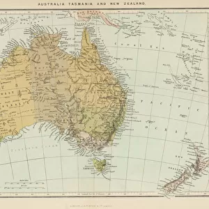
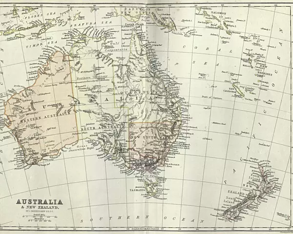
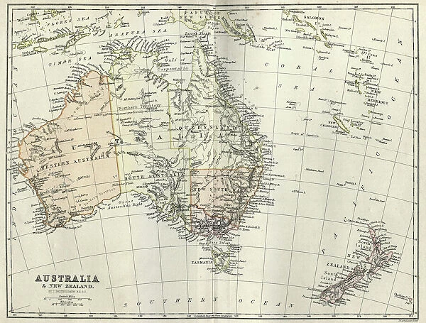
Canvas Print : Antique map of Australia and New Zealand, 1884, 19th Century


![]()
Canvas Prints from Fine Art Storehouse
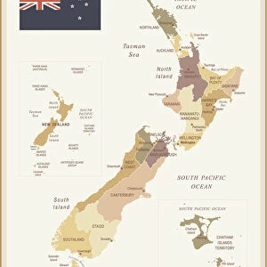
Antique map of Australia and New Zealand, 1884, 19th Century
Unleash your creativity and transform your space into a visual masterpiece!
duncan1890
Media ID 19684263
20"x16" (51x41cm) Canvas Print
"Step back in time with our stunning antique map of Australia and New Zealand, a beautiful piece from the 19th Century by duncan1890 from our Fine Art Storehouse. This vintage canvas print showcases intricate cartographic details and historical landmarks, transporting you to a bygone era. Perfectly preserved, the rich colors and textures of this antique map are brought to life on high-quality canvas, ensuring a timeless addition to any room in your home or office. Add a touch of history and character to your decor with this exquisite canvas print."
Delivered stretched and ready to hang our premium quality canvas prints are made from a polyester/cotton blend canvas and stretched over a 1.25" (32mm) kiln dried knot free wood stretcher bar. Packaged in a plastic bag and secured to a cardboard insert for safe transit.
Canvas Prints add colour, depth and texture to any space. Professionally Stretched Canvas over a hidden Wooden Box Frame and Ready to Hang
Estimated Product Size is 50.8cm x 40.6cm (20" x 16")
These are individually made so all sizes are approximate
Artwork printed orientated as per the preview above, with landscape (horizontal) orientation to match the source image.
FEATURES IN THESE COLLECTIONS
> Maps and Charts
> Related Images
> Oceania
> Australia
> Related Images
> Oceania
> New Zealand
> Maps
> Oceania
> New Zealand
> Related Images
> Fine Art Storehouse
> Map
> Historical Maps
EDITORS COMMENTS
This print showcases an exquisite antique map of Australia and New Zealand, dating back to the year 1884. A true relic from the 19th century, this piece of cartographic art takes us on a journey through time, offering a glimpse into the past when exploration and discovery were at their peak. The intricate details of this map are brought to life through expert engraving techniques that highlight every contour and coastline with precision. As we gaze upon it, we can almost feel the sense of adventure that must have filled the hearts of those who embarked on voyages across these vast lands. Australia's expansive terrain is beautifully depicted, showcasing its diverse landscapes from arid deserts to lush rainforests. Meanwhile, New Zealand's enchanting islands emerge gracefully amidst the vastness of the Pacific Ocean. This remarkable artwork not only serves as a testament to human curiosity but also pays homage to the craftsmanship involved in creating such masterpieces during an era where technology was limited. It reminds us of how far we have come in our understanding and mapping of our world. Duncan1890's print captures all these elements flawlessly, allowing us to appreciate this antique map in all its glory. Whether you're a history enthusiast or simply drawn to vintage aesthetics, this piece will undoubtedly add character and sophistication to any space it graces.
MADE IN THE USA
Safe Shipping with 30 Day Money Back Guarantee
FREE PERSONALISATION*
We are proud to offer a range of customisation features including Personalised Captions, Color Filters and Picture Zoom Tools
SECURE PAYMENTS
We happily accept a wide range of payment options so you can pay for the things you need in the way that is most convenient for you
* Options may vary by product and licensing agreement. Zoomed Pictures can be adjusted in the Cart.