Jigsaw Puzzle > Oceania > New Zealand > Maps
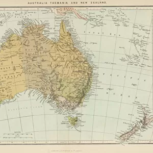
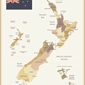
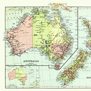
Jigsaw Puzzle : Antique map of Australia and New Zealand, 1884, 19th Century


![]()
Jigsaw Puzzles from Fine Art Storehouse
Antique map of Australia and New Zealand, 1884, 19th Century
Unleash your creativity and transform your space into a visual masterpiece!
duncan1890
Media ID 19684263
Jigsaw Puzzle (520 Pieces)
Discover the rich history of Australia and New Zealand with our captivating jigsaw puzzle from Media Storehouse. This intricately detailed puzzle features an antique map of the region, dating back to 1884. The 19th century design by duncan1890 from Fine Art Storehouse brings the intriguing cartography of yesteryears to life. Immerse yourself in the puzzle's charming vintage aesthetic as you piece together the continents, islands, and intricate borders. A perfect addition to your collection or a delightful activity for the whole family, this antique map puzzle offers a fun and educational experience, transporting you back in time.
Made in the USA, 520-piece puzzles measure 16" x 20" (40.6 x 50.8 cm). Every puzzle is meticulously printed on glossy photo paper, which has a strong 1.33 mm thickness. Delivered in a black storage cardboard box, these puzzles are both stylish and practical. (Note: puzzles contain small parts and are not suitable for children under 3 years of age.)
Jigsaw Puzzles are an ideal gift for any occasion
Estimated Product Size is 50.8cm x 40.5cm (20" x 15.9")
These are individually made so all sizes are approximate
Artwork printed orientated as per the preview above, with landscape (horizontal) or portrait (vertical) orientation to match the source image.
FEATURES IN THESE COLLECTIONS
> Fine Art Storehouse
> Map
> Historical Maps
> Maps and Charts
> Related Images
> Oceania
> Australia
> Related Images
> Oceania
> New Zealand
> Maps
> Oceania
> New Zealand
> Related Images
EDITORS COMMENTS
This print showcases an exquisite antique map of Australia and New Zealand, dating back to the year 1884. A true relic from the 19th century, this piece of cartographic art takes us on a journey through time, offering a glimpse into the past when exploration and discovery were at their peak. The intricate details of this map are brought to life through expert engraving techniques that highlight every contour and coastline with precision. As we gaze upon it, we can almost feel the sense of adventure that must have filled the hearts of those who embarked on voyages across these vast lands. Australia's expansive terrain is beautifully depicted, showcasing its diverse landscapes from arid deserts to lush rainforests. Meanwhile, New Zealand's enchanting islands emerge gracefully amidst the vastness of the Pacific Ocean. This remarkable artwork not only serves as a testament to human curiosity but also pays homage to the craftsmanship involved in creating such masterpieces during an era where technology was limited. It reminds us of how far we have come in our understanding and mapping of our world. Duncan1890's print captures all these elements flawlessly, allowing us to appreciate this antique map in all its glory. Whether you're a history enthusiast or simply drawn to vintage aesthetics, this piece will undoubtedly add character and sophistication to any space it graces.
MADE IN THE USA
Safe Shipping with 30 Day Money Back Guarantee
FREE PERSONALISATION*
We are proud to offer a range of customisation features including Personalised Captions, Color Filters and Picture Zoom Tools
SECURE PAYMENTS
We happily accept a wide range of payment options so you can pay for the things you need in the way that is most convenient for you
* Options may vary by product and licensing agreement. Zoomed Pictures can be adjusted in the Cart.