Canvas Print > Africa > Egypt > Maps
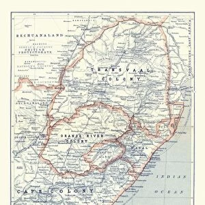
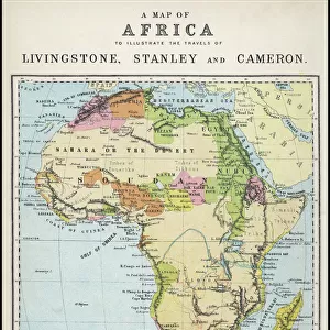
Canvas Print : Map of Africa 1895


![]()
Canvas Prints from Fine Art Storehouse
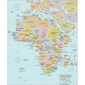
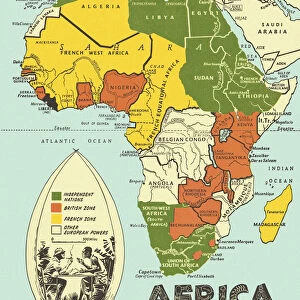
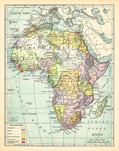
Map of Africa 1895
The Rand-McNally Grammar School Geography 1895 - Chicago & New York
Unleash your creativity and transform your space into a visual masterpiece!
THEPALMER
Media ID 14824631
© This content is subject to copyright
Central Africa East Africa Egypt Madagascar Sahara Somalia South Africa Sudan
20"x16" (51x41cm) Canvas Print
Step back in time with our exquisite Canvas Print of the Map of Africa 1895 by THEPALMER from our Media Storehouse Fine Art collection. This captivating vintage map, originally published by Rand-McNally for grammar school geography in 1895, adds an intriguing historical touch to any room. The high-quality canvas print boasts stunning detail and vibrant colors, making it a beautiful conversation starter and a unique addition to your home or office decor. Travel back in time and explore the world's history with this fascinating piece of art.
Delivered stretched and ready to hang our premium quality canvas prints are made from a polyester/cotton blend canvas and stretched over a 1.25" (32mm) kiln dried knot free wood stretcher bar. Packaged in a plastic bag and secured to a cardboard insert for safe transit.
Canvas Prints add colour, depth and texture to any space. Professionally Stretched Canvas over a hidden Wooden Box Frame and Ready to Hang
Estimated Product Size is 40.6cm x 50.8cm (16" x 20")
These are individually made so all sizes are approximate
Artwork printed orientated as per the preview above, with portrait (vertical) orientation to match the source image.
FEATURES IN THESE COLLECTIONS
> Africa
> Egypt
> Related Images
> Africa
> Madagascar
> Maps
> Africa
> Madagascar
> Related Images
> Africa
> Related Images
> Africa
> Somalia
> Related Images
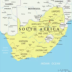
> Africa
> South Africa
> Maps
> Africa
> South Africa
> Related Images
> Africa
> South Sudan
> Maps
> Fine Art Storehouse
> Map
> Historical Maps
EDITORS COMMENTS
This photo print, titled "Map of Africa 1895" takes us on a journey back in time to the late 19th century. The map, sourced from the renowned Rand-McNally Grammar School Geography book published in Chicago and New York, offers a glimpse into the intricate details and vastness of the African continent as it was known over a century ago. The map showcases various regions including Central Africa, East Africa, Egypt, Madagascar, Sahara Desert, Somalia, South Africa, Sudan and more. With its rich colors and meticulous cartographic workmanship by THEPALMER artist from Fine Art Storehouse collection; this piece is not only visually stunning but also historically significant. As we gaze upon this vintage treasure hanging on our walls or displayed in an art gallery setting; we are transported to an era when exploration was at its peak. It reminds us of the intrepid adventurers who embarked on daring expeditions across uncharted territories within Africa's diverse landscapes. Beyond its aesthetic appeal lies a deeper appreciation for the cultural heritage and geographical knowledge that has shaped our understanding of this magnificent continent. This artwork serves as a testament to human curiosity and discovery while honoring the craftsmanship involved in creating such detailed maps during an era without modern technology. "Map of Africa 1895" invites us to reflect on how far we have come since then while igniting our wanderlust for exploring new horizons both geographically and intellectually.
MADE IN THE USA
Safe Shipping with 30 Day Money Back Guarantee
FREE PERSONALISATION*
We are proud to offer a range of customisation features including Personalised Captions, Color Filters and Picture Zoom Tools
SECURE PAYMENTS
We happily accept a wide range of payment options so you can pay for the things you need in the way that is most convenient for you
* Options may vary by product and licensing agreement. Zoomed Pictures can be adjusted in the Cart.