Canvas Print > Europe > United Kingdom > Scotland > Fife > Falkland
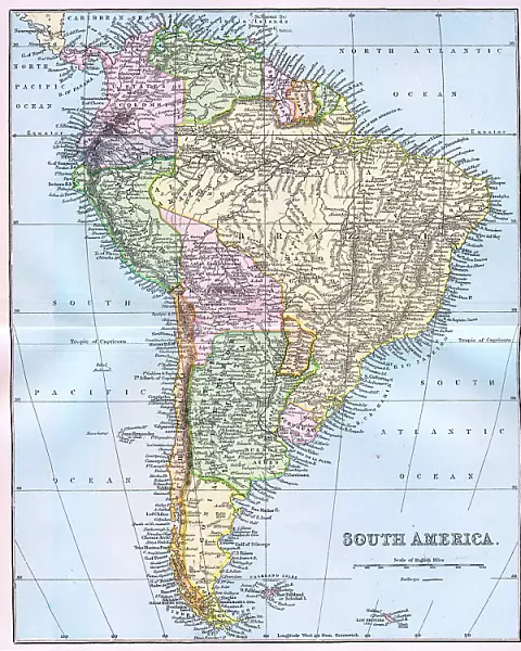
Canvas Print : Map of South America 19th Century


![]()
Canvas Prints from Fine Art Storehouse
Map of South America 19th Century
Vintage map of South America from the 19th Century
Unleash your creativity and transform your space into a visual masterpiece!
duncan1890
Media ID 31661293
© duncan1890
Amazon Region Argentina Bolivia Brazil Chile Colombia Ecuador Falkland Islands Guyana Navigational Equipment Objects Equipment Paraguay Patagonia Peru South America Travel Locations Uruguay Venezuela Amazonia French Guiana Obsolete Suriname Tierra Del Fuego
20"x16" (51x41cm) Canvas Print
Step back in time with our exquisite Canvas Print of a Vintage Map of South America from the 19th Century, beautifully crafted by duncan1890 from our Media Storehouse Fine Art collection. This captivating piece of historical art transports you to an era of exploration and discovery. The intricate details of the map are brought to life in stunning detail on the textured canvas, making it a perfect addition to any room in your home or office. Embrace the charm of the past with this unique and authentic work of art.
Delivered stretched and ready to hang our premium quality canvas prints are made from a polyester/cotton blend canvas and stretched over a 1.25" (32mm) kiln dried knot free wood stretcher bar. Packaged in a plastic bag and secured to a cardboard insert for safe transit.
Canvas Prints add colour, depth and texture to any space. Professionally Stretched Canvas over a hidden Wooden Box Frame and Ready to Hang
Estimated Product Size is 40.6cm x 50.8cm (16" x 20")
These are individually made so all sizes are approximate
Artwork printed orientated as per the preview above, with portrait (vertical) orientation to match the source image.
FEATURES IN THESE COLLECTIONS
> Europe
> United Kingdom
> Scotland
> Fife
> Falkland
> Maps and Charts
> Related Images
> South America
> Argentina
> Maps
> South America
> Argentina
> Related Images
> South America
> Bolivia
> Maps
> South America
> Bolivia
> Related Images
> South America
> Brazil
> Maps
> Fine Art Storehouse
> Map
> Historical Maps
EDITORS COMMENTS
This vintage print showcases a Map of South America from the 19th Century, taking us on a journey through time. The intricate details and faded colors evoke a sense of nostalgia, transporting us to an era when exploration and discovery were at their peak. The map highlights various regions within South America, including the Amazon region, Tierra del Fuego, Falkland Islands, and the Southern Atlantic Islands. Each area is carefully labeled with names that have stood the test of time - Venezuela, Uruguay, Suriname, Peru, Paraguay - reminding us of the rich history embedded in this vast continent. As we gaze upon this old-fashioned piece of artistry, we can almost imagine explorers using similar navigational equipment to chart their course across these uncharted lands. It serves as a reminder of how far we've come in terms of technological advancements. This antique map also offers glimpses into lesser-known territories such as French Guiana and Patagonia while showcasing well-known countries like Brazil and Argentina. Its presence invites us to embark on our own imaginary voyage through these diverse landscapes. Whether you are an avid traveler or simply appreciate historical artifacts, this print by Duncan1890 captures both beauty and curiosity in one frame. Hang it proudly on your wall as a testament to the ever-changing world around us or use it as inspiration for your next adventure off the beaten path.
MADE IN THE USA
Safe Shipping with 30 Day Money Back Guarantee
FREE PERSONALISATION*
We are proud to offer a range of customisation features including Personalised Captions, Color Filters and Picture Zoom Tools
SECURE PAYMENTS
We happily accept a wide range of payment options so you can pay for the things you need in the way that is most convenient for you
* Options may vary by product and licensing agreement. Zoomed Pictures can be adjusted in the Cart.