Jigsaw Puzzle > Europe > United Kingdom > Scotland > Fife > Falkland
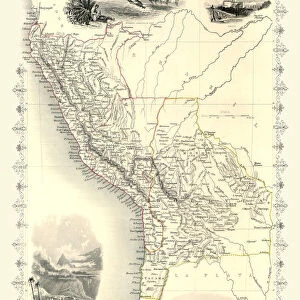
Jigsaw Puzzle : Map of South America 19th Century


![]()
Jigsaw Puzzles from Fine Art Storehouse
Map of South America 19th Century
Vintage map of South America from the 19th Century
Unleash your creativity and transform your space into a visual masterpiece!
duncan1890
Media ID 31661293
© duncan1890
Amazon Region Argentina Bolivia Brazil Chile Colombia Ecuador Falkland Islands Guyana Navigational Equipment Objects Equipment Paraguay Patagonia Peru South America Travel Locations Uruguay Venezuela Amazonia French Guiana Obsolete Suriname Tierra Del Fuego
Jigsaw Puzzle (520 Pieces)
Discover the past with our captivating Map of South America 19th Century jigsaw puzzle from the Fine Art Storehouse collection by duncan1890. Travel back in time as you piece together this intricately detailed vintage map, showcasing the political boundaries and geographical features of South America during the 19th century. Ideal for puzzle enthusiasts and history buffs alike, immerse yourself in the rich history of this fascinating continent while enjoying the satisfaction of completing a beautiful and challenging puzzle.
Made in the USA, 520-piece puzzles measure 16" x 20" (40.6 x 50.8 cm). Every puzzle is meticulously printed on glossy photo paper, which has a strong 1.33 mm thickness. Delivered in a black storage cardboard box, these puzzles are both stylish and practical. (Note: puzzles contain small parts and are not suitable for children under 3 years of age.)
Jigsaw Puzzles are an ideal gift for any occasion
Estimated Product Size is 40.5cm x 50.8cm (15.9" x 20")
These are individually made so all sizes are approximate
Artwork printed orientated as per the preview above, with landscape (horizontal) or portrait (vertical) orientation to match the source image.
FEATURES IN THESE COLLECTIONS
> Fine Art Storehouse
> Map
> Historical Maps
> Europe
> United Kingdom
> Scotland
> Fife
> Falkland
> Maps and Charts
> Related Images
> South America
> Argentina
> Maps
> South America
> Argentina
> Related Images
> South America
> Bolivia
> Maps
> South America
> Bolivia
> Related Images
> South America
> Brazil
> Maps
EDITORS COMMENTS
This vintage print showcases a Map of South America from the 19th Century, taking us on a journey through time. The intricate details and faded colors evoke a sense of nostalgia, transporting us to an era when exploration and discovery were at their peak. The map highlights various regions within South America, including the Amazon region, Tierra del Fuego, Falkland Islands, and the Southern Atlantic Islands. Each area is carefully labeled with names that have stood the test of time - Venezuela, Uruguay, Suriname, Peru, Paraguay - reminding us of the rich history embedded in this vast continent. As we gaze upon this old-fashioned piece of artistry, we can almost imagine explorers using similar navigational equipment to chart their course across these uncharted lands. It serves as a reminder of how far we've come in terms of technological advancements. This antique map also offers glimpses into lesser-known territories such as French Guiana and Patagonia while showcasing well-known countries like Brazil and Argentina. Its presence invites us to embark on our own imaginary voyage through these diverse landscapes. Whether you are an avid traveler or simply appreciate historical artifacts, this print by Duncan1890 captures both beauty and curiosity in one frame. Hang it proudly on your wall as a testament to the ever-changing world around us or use it as inspiration for your next adventure off the beaten path.
MADE IN THE USA
Safe Shipping with 30 Day Money Back Guarantee
FREE PERSONALISATION*
We are proud to offer a range of customisation features including Personalised Captions, Color Filters and Picture Zoom Tools
SECURE PAYMENTS
We happily accept a wide range of payment options so you can pay for the things you need in the way that is most convenient for you
* Options may vary by product and licensing agreement. Zoomed Pictures can be adjusted in the Cart.