Canvas Print > Maps and Charts > Related Images
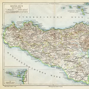
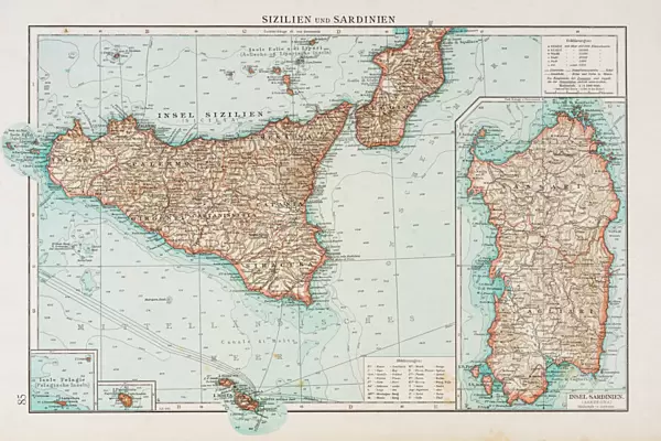
Canvas Print : Sardinia and Sicily map 1896


![]()
Canvas Prints from Fine Art Storehouse
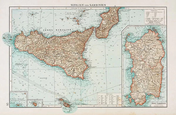
Sardinia and Sicily map 1896
Andres Allgemeiner Handatlas - Bielefeld und Leipzig 1896
Unleash your creativity and transform your space into a visual masterpiece!
THEPALMER
Media ID 18356789
30"x20" (76x51cm) Canvas Print
"Transport yourself back in time with our stunning Canvas Print of "Sardinia and Sicily Map 1896" by THEPALMER from our Media Storehouse collection. This exquisite piece, taken from the Andres Allgemeiner Handatlas published in Bielefeld and Leipzig in 1896, showcases intricate cartographic detail and historical accuracy. The high-quality canvas print brings the rich history of these two beautiful islands to life in your home or office, making it a perfect addition to any decor. Experience the charm of the past with our Canvas Print of Sardinia and Sicily Map 1896."
Delivered stretched and ready to hang our premium quality canvas prints are made from a polyester/cotton blend canvas and stretched over a 1.25" (32mm) kiln dried knot free wood stretcher bar. Packaged in a plastic bag and secured to a cardboard insert for safe transit.
Canvas Prints add colour, depth and texture to any space. Professionally Stretched Canvas over a hidden Wooden Box Frame and Ready to Hang
Estimated Product Size is 76.2cm x 50.8cm (30" x 20")
These are individually made so all sizes are approximate
Artwork printed orientated as per the preview above, with landscape (horizontal) orientation to match the source image.
FEATURES IN THESE COLLECTIONS
> Europe
> Italy
> Sardinia
> Related Images
> Europe
> Italy
> Sicily
> Related Images
> Maps and Charts
> Related Images
> Fine Art Storehouse
> Map
> Historical Maps
EDITORS COMMENTS
This print showcases a historic map of Sardinia and Sicily from 1896, taken from Andres Allgemeiner Handatlas - Bielefeld und Leipzig. With intricate details and exquisite craftsmanship, this piece offers a glimpse into the past, inviting us to explore the rich geography of these Mediterranean islands. The map itself is a testament to the artistry and precision of cartography in the late 19th century. Every contour, river, and coastline is meticulously rendered with utmost accuracy, reflecting the dedication and expertise of its creator. The delicate color palette adds an elegant touch to this vintage masterpiece, enhancing its allure as both a work of art and historical documentation. As we gaze upon this print by THEPALMER from Fine Art Storehouse, we are transported back in time to an era when maps were not just navigational tools but also works of beauty that captured our imagination. It serves as a reminder that even in today's digital age, there is still something enchanting about holding a physical representation of our world in our hands. Whether you have an appreciation for history or simply admire fine art prints, this Sardinia and Sicily map will undoubtedly be a striking addition to any collection or decor. Its timeless charm transcends generations while offering endless opportunities for exploration within its intricate contours.
MADE IN THE USA
Safe Shipping with 30 Day Money Back Guarantee
FREE PERSONALISATION*
We are proud to offer a range of customisation features including Personalised Captions, Color Filters and Picture Zoom Tools
SECURE PAYMENTS
We happily accept a wide range of payment options so you can pay for the things you need in the way that is most convenient for you
* Options may vary by product and licensing agreement. Zoomed Pictures can be adjusted in the Cart.