Fine Art Print > Maps and Charts > Related Images
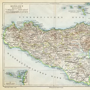
Fine Art Print : Sardinia and Sicily map 1896


![]()
Fine Art Prints from Fine Art Storehouse
Sardinia and Sicily map 1896
Andres Allgemeiner Handatlas - Bielefeld und Leipzig 1896
Unleash your creativity and transform your space into a visual masterpiece!
THEPALMER
Media ID 18356789
21"x14" (+3" Border) Fine Art Print
Discover the rich history and culture of Sardinia and Sicily with this exquisite antique map print from the Media Storehouse Fine Art Prints collection. Originally published in the Andres Allgemeiner Handatlas of 1896 by THEPALMER in Bielefeld and Leipzig, this detailed map showcases the intricate geography and political boundaries of the two Italian islands during that time. Bring a piece of historical cartography into your home or office and transport yourself to the Mediterranean with this stunning fine art print.
21x14 image printed on 27x20 Fine Art Rag Paper with 3" (76mm) white border. Our Fine Art Prints are printed on 300gsm 100% acid free, PH neutral paper with archival properties. This printing method is used by museums and art collections to exhibit photographs and art reproductions.
Our fine art prints are high-quality prints made using a paper called Photo Rag. This 100% cotton rag fibre paper is known for its exceptional image sharpness, rich colors, and high level of detail, making it a popular choice for professional photographers and artists. Photo rag paper is our clear recommendation for a fine art paper print. If you can afford to spend more on a higher quality paper, then Photo Rag is our clear recommendation for a fine art paper print.
Estimated Image Size (if not cropped) is 53.3cm x 35.5cm (21" x 14")
Estimated Product Size is 68.6cm x 50.8cm (27" x 20")
These are individually made so all sizes are approximate
Artwork printed orientated as per the preview above, with landscape (horizontal) orientation to match the source image.
FEATURES IN THESE COLLECTIONS
> Europe
> Italy
> Sardinia
> Related Images
> Europe
> Italy
> Sicily
> Related Images
> Maps and Charts
> Related Images
> Fine Art Storehouse
> Map
> Historical Maps
EDITORS COMMENTS
This print showcases a historic map of Sardinia and Sicily from 1896, taken from Andres Allgemeiner Handatlas - Bielefeld und Leipzig. With intricate details and exquisite craftsmanship, this piece offers a glimpse into the past, inviting us to explore the rich geography of these Mediterranean islands. The map itself is a testament to the artistry and precision of cartography in the late 19th century. Every contour, river, and coastline is meticulously rendered with utmost accuracy, reflecting the dedication and expertise of its creator. The delicate color palette adds an elegant touch to this vintage masterpiece, enhancing its allure as both a work of art and historical documentation. As we gaze upon this print by THEPALMER from Fine Art Storehouse, we are transported back in time to an era when maps were not just navigational tools but also works of beauty that captured our imagination. It serves as a reminder that even in today's digital age, there is still something enchanting about holding a physical representation of our world in our hands. Whether you have an appreciation for history or simply admire fine art prints, this Sardinia and Sicily map will undoubtedly be a striking addition to any collection or decor. Its timeless charm transcends generations while offering endless opportunities for exploration within its intricate contours.
MADE IN THE USA
Safe Shipping with 30 Day Money Back Guarantee
FREE PERSONALISATION*
We are proud to offer a range of customisation features including Personalised Captions, Color Filters and Picture Zoom Tools
SECURE PAYMENTS
We happily accept a wide range of payment options so you can pay for the things you need in the way that is most convenient for you
* Options may vary by product and licensing agreement. Zoomed Pictures can be adjusted in the Cart.