Canvas Print > Maps and Charts > Americas
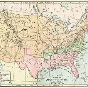
Canvas Print : Southern Confederacy Map 1895


![]()
Canvas Prints from Fine Art Storehouse
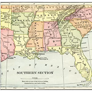
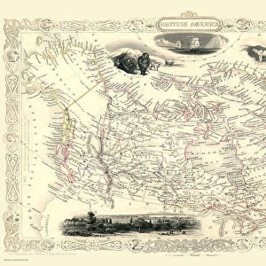
Southern Confederacy Map 1895
Map from " A History of the United States for America. The Confederate States of America, commonly referred to as the Confederacy, was an unrecognized republic in North America that existed from 1861 to 1865
Unleash your creativity and transform your space into a visual masterpiece!
THEPALMER
Media ID 19916133
© A 2014 Roberto Adrian Photography
30"x20" (76x51cm) Canvas Print
Step back in time with our exquisite Canvas Print of the Southern Confederacy Map 1895 from THEPALMER's "A History of the United States for America: The Confederate States of America." This captivating piece of historical art brings to life the intricate details of the Confederate territories during that era. The high-quality canvas print boasts vibrant colors and sharp details, making it a stunning addition to any room in your home or office. Perfect for history enthusiasts, educators, or anyone who appreciates the beauty of fine art, this canvas print is sure to impress. Order yours today and bring a piece of the past into your present.
Delivered stretched and ready to hang our premium quality canvas prints are made from a polyester/cotton blend canvas and stretched over a 1.25" (32mm) kiln dried knot free wood stretcher bar. Packaged in a plastic bag and secured to a cardboard insert for safe transit.
Canvas Prints add colour, depth and texture to any space. Professionally Stretched Canvas over a hidden Wooden Box Frame and Ready to Hang
Estimated Product Size is 76.2cm x 50.8cm (30" x 20")
These are individually made so all sizes are approximate
Artwork printed orientated as per the preview above, with landscape (horizontal) orientation to match the source image.
FEATURES IN THESE COLLECTIONS
> Maps and Charts
> Related Images
> Fine Art Storehouse
> Map
> Historical Maps
EDITORS COMMENTS
This print showcases the Southern Confederacy Map from 1895, sourced from "A History of the United States for America". The map itself is a historical gem, representing an era that shaped North American history. The Confederate States of America, known as the Confederacy, emerged as an unrecognized republic between 1861 and 1865. The map's intricate details transport us back to a time when borders were redrawn and ideologies clashed. It serves as a visual testament to the turbulent period in which it was created. Every contour line and boundary on this map tells a story of struggle and division. "The Southern Confederacy Map" offers viewers a glimpse into the geographical landscape that defined this short-lived nation. With its delicate hues and precise cartographic markings, it invites exploration into the heartland of Confederate territory during those tumultuous years. As we gaze upon this remarkable piece by THEPALMER from Fine Art Storehouse, we are reminded of how art can encapsulate history within its very brushstrokes or ink lines. This photograph print preserves not only an important historical artifact but also captures our curiosity about past events that continue to shape our present world.
MADE IN THE USA
Safe Shipping with 30 Day Money Back Guarantee
FREE PERSONALISATION*
We are proud to offer a range of customisation features including Personalised Captions, Color Filters and Picture Zoom Tools
SECURE PAYMENTS
We happily accept a wide range of payment options so you can pay for the things you need in the way that is most convenient for you
* Options may vary by product and licensing agreement. Zoomed Pictures can be adjusted in the Cart.