Fine Art Print > Maps and Charts > Americas
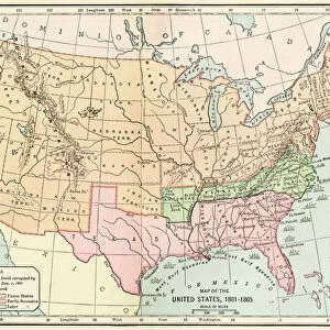
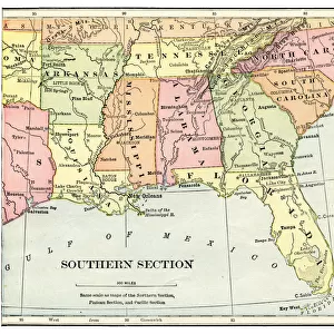
Fine Art Print : Southern Confederacy Map 1895


![]()
Fine Art Prints from Fine Art Storehouse
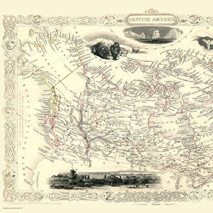
Southern Confederacy Map 1895
Map from " A History of the United States for America. The Confederate States of America, commonly referred to as the Confederacy, was an unrecognized republic in North America that existed from 1861 to 1865
Unleash your creativity and transform your space into a visual masterpiece!
THEPALMER
Media ID 19916133
© A 2014 Roberto Adrian Photography
21"x14" (+3" Border) Fine Art Print
Step into the past with our exquisite Southern Confederacy Map 1895 print from THEPALMER's A History of the United States for America collection at Fine Art Storehouse. This fine art print transports you back in time, offering a captivating glimpse into the historical landscape of the Confederate States of America. The intricate details of the map, from the borders of the various states to the winding rivers and railroads, make for a stunning addition to any home or office. Bring history to life with this beautiful and authentic piece of art.
21x14 image printed on 27x20 Fine Art Rag Paper with 3" (76mm) white border. Our Fine Art Prints are printed on 300gsm 100% acid free, PH neutral paper with archival properties. This printing method is used by museums and art collections to exhibit photographs and art reproductions.
Our fine art prints are high-quality prints made using a paper called Photo Rag. This 100% cotton rag fibre paper is known for its exceptional image sharpness, rich colors, and high level of detail, making it a popular choice for professional photographers and artists. Photo rag paper is our clear recommendation for a fine art paper print. If you can afford to spend more on a higher quality paper, then Photo Rag is our clear recommendation for a fine art paper print.
Estimated Image Size (if not cropped) is 53.3cm x 33.1cm (21" x 13")
Estimated Product Size is 68.6cm x 50.8cm (27" x 20")
These are individually made so all sizes are approximate
Artwork printed orientated as per the preview above, with landscape (horizontal) orientation to match the source image.
FEATURES IN THESE COLLECTIONS
> Maps and Charts
> Related Images
> Fine Art Storehouse
> Map
> Historical Maps
EDITORS COMMENTS
This print showcases the Southern Confederacy Map from 1895, sourced from "A History of the United States for America". The map itself is a historical gem, representing an era that shaped North American history. The Confederate States of America, known as the Confederacy, emerged as an unrecognized republic between 1861 and 1865. The map's intricate details transport us back to a time when borders were redrawn and ideologies clashed. It serves as a visual testament to the turbulent period in which it was created. Every contour line and boundary on this map tells a story of struggle and division. "The Southern Confederacy Map" offers viewers a glimpse into the geographical landscape that defined this short-lived nation. With its delicate hues and precise cartographic markings, it invites exploration into the heartland of Confederate territory during those tumultuous years. As we gaze upon this remarkable piece by THEPALMER from Fine Art Storehouse, we are reminded of how art can encapsulate history within its very brushstrokes or ink lines. This photograph print preserves not only an important historical artifact but also captures our curiosity about past events that continue to shape our present world.
MADE IN THE USA
Safe Shipping with 30 Day Money Back Guarantee
FREE PERSONALISATION*
We are proud to offer a range of customisation features including Personalised Captions, Color Filters and Picture Zoom Tools
SECURE PAYMENTS
We happily accept a wide range of payment options so you can pay for the things you need in the way that is most convenient for you
* Options may vary by product and licensing agreement. Zoomed Pictures can be adjusted in the Cart.