Canvas Print > Maps and Charts > Americas
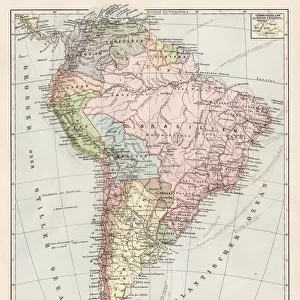
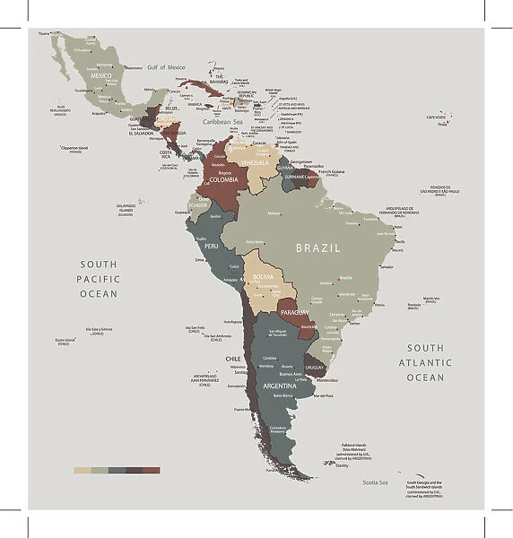
Canvas Print : South America map countries and cities


![]()
Canvas Prints from Fine Art Storehouse
South America map countries and cities
Vector illustration of South America map
Unleash your creativity and transform your space into a visual masterpiece!
Media ID 14457387
20"x16" (51x41cm) Canvas Print
"Discover the vibrant cultures and diverse landscapes of South America with our stunning Canvas Print from Media Storehouse's Fine Art Collection. This beautifully illustrated map of South America showcases the distinct countries and cities, bringing the richness of the region right into your home or office. Our high-quality Canvas Prints are meticulously crafted using premium materials, ensuring a long-lasting and eye-catching display. Elevate your decor with this captivating representation of the South American continent."
Delivered stretched and ready to hang our premium quality canvas prints are made from a polyester/cotton blend canvas and stretched over a 1.25" (32mm) kiln dried knot free wood stretcher bar. Packaged in a plastic bag and secured to a cardboard insert for safe transit.
Canvas Prints add colour, depth and texture to any space. Professionally Stretched Canvas over a hidden Wooden Box Frame and Ready to Hang
Estimated Product Size is 40.6cm x 50.8cm (16" x 20")
These are individually made so all sizes are approximate
Artwork printed orientated as per the preview above, with portrait (vertical) orientation to match the source image.
FEATURES IN THESE COLLECTIONS
> Maps and Charts
> Related Images
> South America
> Related Images
EDITORS COMMENTS
This print showcases a beautifully detailed vector illustration of the South America map, highlighting its countries and cities. The intricate design captures the essence of this diverse continent, inviting viewers to embark on a visual journey through its rich cultural heritage. From the vibrant streets of Rio de Janeiro to the ancient ruins of Machu Picchu, this artwork encapsulates the allure and mystique that South America exudes. Each country is meticulously outlined with precision, allowing us to appreciate their unique shapes and sizes. As our eyes wander across the map, we are drawn towards bustling metropolises like Buenos Aires and Santiago, as well as hidden gems such as Cartagena and Cusco. The colors chosen for this illustration evoke a sense of warmth and vibrancy, mirroring the lively spirit found throughout South America. Shades of green symbolize lush rainforests while shades of blue represent vast oceans surrounding these magnificent lands. Whether you have traveled extensively in South America or dreamt about exploring its wonders someday, this print serves as an exquisite reminder of all that awaits within this enchanting continent. Hang it on your wall to ignite conversations about past adventures or inspire future ones.
MADE IN THE USA
Safe Shipping with 30 Day Money Back Guarantee
FREE PERSONALISATION*
We are proud to offer a range of customisation features including Personalised Captions, Color Filters and Picture Zoom Tools
SECURE PAYMENTS
We happily accept a wide range of payment options so you can pay for the things you need in the way that is most convenient for you
* Options may vary by product and licensing agreement. Zoomed Pictures can be adjusted in the Cart.