Jigsaw Puzzle > Maps and Charts > Americas
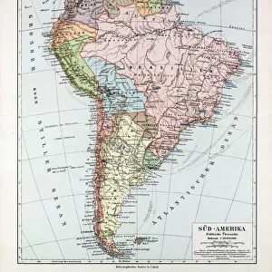
Jigsaw Puzzle : South America map countries and cities


![]()
Jigsaw Puzzles from Fine Art Storehouse
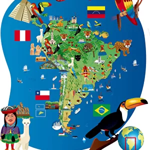
South America map countries and cities
Vector illustration of South America map
Unleash your creativity and transform your space into a visual masterpiece!
Media ID 14457387
Jigsaw Puzzle (520 Pieces)
Discover the wonders of South America with our captivating jigsaw puzzles from Media Storehouse's Fine Art Storehouse collection. This intricately detailed puzzle showcases a stunning vector illustration of the South America map, featuring the distinctive outlines of countries and the vibrant cities that call this continent home. Engage your mind and challenge your problem-solving skills as you piece together this beautiful puzzle, making it a perfect activity for families, friends, or individuals seeking a relaxing and rewarding pastime. Immerse yourself in the rich cultural heritage and diverse landscapes of South America as you bring this puzzle to life. Order now and embark on an educational and enjoyable journey!
Made in the USA, 520-piece puzzles measure 16" x 20" (40.6 x 50.8 cm). Every puzzle is meticulously printed on glossy photo paper, which has a strong 1.33 mm thickness. Delivered in a black storage cardboard box, these puzzles are both stylish and practical. (Note: puzzles contain small parts and are not suitable for children under 3 years of age.)
Jigsaw Puzzles are an ideal gift for any occasion
Estimated Product Size is 40.5cm x 50.8cm (15.9" x 20")
These are individually made so all sizes are approximate
Artwork printed orientated as per the preview above, with landscape (horizontal) or portrait (vertical) orientation to match the source image.
FEATURES IN THESE COLLECTIONS
> Maps and Charts
> Related Images
> South America
> Related Images
EDITORS COMMENTS
This print showcases a beautifully detailed vector illustration of the South America map, highlighting its countries and cities. The intricate design captures the essence of this diverse continent, inviting viewers to embark on a visual journey through its rich cultural heritage. From the vibrant streets of Rio de Janeiro to the ancient ruins of Machu Picchu, this artwork encapsulates the allure and mystique that South America exudes. Each country is meticulously outlined with precision, allowing us to appreciate their unique shapes and sizes. As our eyes wander across the map, we are drawn towards bustling metropolises like Buenos Aires and Santiago, as well as hidden gems such as Cartagena and Cusco. The colors chosen for this illustration evoke a sense of warmth and vibrancy, mirroring the lively spirit found throughout South America. Shades of green symbolize lush rainforests while shades of blue represent vast oceans surrounding these magnificent lands. Whether you have traveled extensively in South America or dreamt about exploring its wonders someday, this print serves as an exquisite reminder of all that awaits within this enchanting continent. Hang it on your wall to ignite conversations about past adventures or inspire future ones.
MADE IN THE USA
Safe Shipping with 30 Day Money Back Guarantee
FREE PERSONALISATION*
We are proud to offer a range of customisation features including Personalised Captions, Color Filters and Picture Zoom Tools
SECURE PAYMENTS
We happily accept a wide range of payment options so you can pay for the things you need in the way that is most convenient for you
* Options may vary by product and licensing agreement. Zoomed Pictures can be adjusted in the Cart.