Canvas Print > Europe > Republic of Ireland > Maps
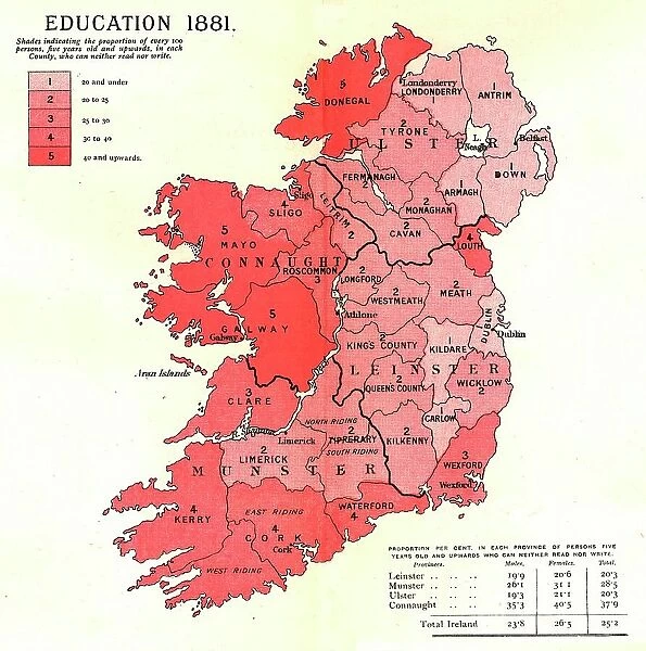
Canvas Print : The Graphic Statistical Maps of Ireland; Education 1881, 1886. Creator: Unknown
![]()

Canvas Prints from Heritage Images
The Graphic Statistical Maps of Ireland; Education 1881, 1886. Creator: Unknown
The Graphic Statistical Maps of Ireland; Education 1881, 1886. From "The Graphic. An Illustrated Weekly Newspaper Volume 33. January to June, 1886"
Heritage Images features heritage image collections
Media ID 36259781
© The Print Collector/Heritage Images
Counties County Eire Ireland Irish Literacy Population Province Provinces Provincial Statistic Statistics
20"x16" (51x41cm) Canvas Print
Step back in time with our exquisite Canvas Print of 'The Graphic Statistical Maps of Ireland: Education 1881' from Media Storehouse. This captivating vintage map, created in 1886 by an unknown artist for The Graphic: An Illustrated Weekly Newspaper, showcases the educational landscape of Ireland during that era. With intricate details and rich colors, this unique piece adds a touch of history and character to any room. Bring the past to life with our premium Canvas Prints, expertly printed on high-quality canvas for lasting brilliance and vibrancy.
Delivered stretched and ready to hang our premium quality canvas prints are made from a polyester/cotton blend canvas and stretched over a 1.25" (32mm) kiln dried knot free wood stretcher bar. Packaged in a plastic bag and secured to a cardboard insert for safe transit.
Canvas Prints add colour, depth and texture to any space. Professionally Stretched Canvas over a hidden Wooden Box Frame and Ready to Hang
Estimated Product Size is 40.6cm x 50.8cm (16" x 20")
These are individually made so all sizes are approximate
Artwork printed orientated as per the preview above, with portrait (vertical) orientation to match the source image.
FEATURES IN THESE COLLECTIONS
> Europe
> Republic of Ireland
> Maps
> Maps and Charts
> Related Images
The Graphic Statistical Maps of Ireland - Education 1881
EDITORS COMMENTS
is an intriguing and enlightening 19th century print depicting the educational landscape of Ireland during that era. The map, created in 1886, was published in "The Graphic: An Illustrated Weekly Newspaper Volume 33, January to June." Although the creator remains unknown, the print offers a captivating glimpse into the educational infrastructure of Ireland during this period. The map employs a colorful and detailed design, with each county in Ireland represented by a distinct hue. The provinces of Ulster, Leinster, Munster, and Connacht are also demarcated, adding to the map's geographical significance. The map's primary focus, however, is on the educational statistics of the time. The map illustrates the literacy rates and school attendance figures for each county, providing a valuable insight into the educational accessibility and quality during the 1880s. The counties with higher literacy rates are depicted in darker shades, while those with lower literacy rates are shown in lighter hues. School attendance is represented by the number of schools in each county, denoted by the small dots scattered across the map. This print serves as an essential historical document, shedding light on the educational conditions in Ireland during the 19th century. It offers a unique perspective on the population distribution, literacy rates, and educational infrastructure of the time, making it an invaluable resource for historians, educators, and anyone interested in the social and cultural history of Ireland. The intricate detail and meticulous design of "The Graphic Statistical Maps of Ireland: Education 1881" make it a captivating addition to any collection of historical maps or prints. Its unknown creator remains a mystery, but the map's enduring significance and the valuable insights it provides into Ireland's educational history make it a truly intriguing and fascinating piece of the past.
MADE IN THE USA
Safe Shipping with 30 Day Money Back Guarantee
FREE PERSONALISATION*
We are proud to offer a range of customisation features including Personalised Captions, Color Filters and Picture Zoom Tools
SECURE PAYMENTS
We happily accept a wide range of payment options so you can pay for the things you need in the way that is most convenient for you
* Options may vary by product and licensing agreement. Zoomed Pictures can be adjusted in the Cart.


