Canvas Print > Europe > United Kingdom > Scotland > Strathclyde > Glasgow
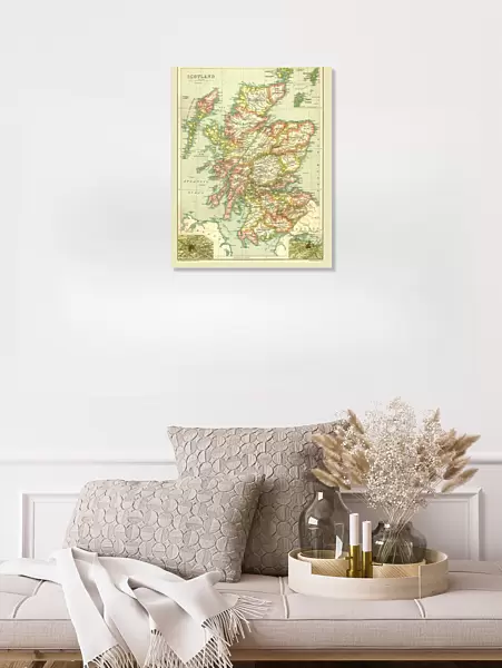
Canvas Print : Map of Scotland, 1902. Creator: Unknown


![]()
Canvas Prints from Heritage Images
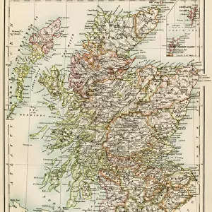
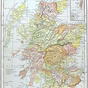
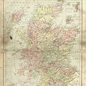
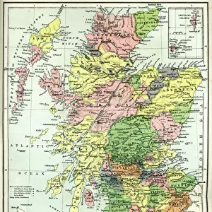
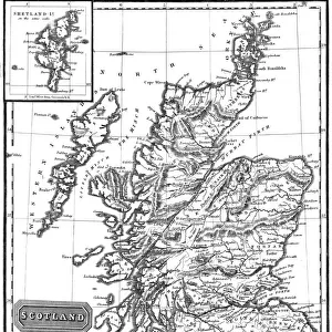
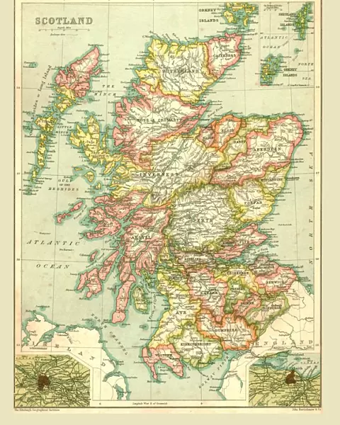
Map of Scotland, 1902. Creator: Unknown
Map of Scotland, 1902. Showing the various counties and islands including the Hebrides, the Shetlands and the Orkneys, and an inset of the rail networks of Glasgow and Edinburgh. From The Century Atlas of the World. [John Walker & Co, Ltd. London, 1902]
Heritage Images features heritage image collections
Media ID 15512564
© The Print Collector / Heritage-Images
Counties County Edinburgh Geographical Institute Hebrides Orkney Islands Orkneys Shetland Islands
20"x16" (51x41cm) Canvas Print
Discover the rich history of Scotland with our stunning Canvas Print of a rare and intriguing Map of Scotland from 1902. This beautiful vintage map, sourced from Heritage Images, showcases the detailed cartography of the time, highlighting the various counties, islands, and rail networks of Glasgow and Edinburgh. With the inclusion of the Hebrides, Shetlands, and Orkneys, this map is a must-have for anyone with a love for Scottish history or geography. Bring the past into your home and add character to any room with this captivating piece of art. Order your Canvas Print from the Media Storehouse range today.
Delivered stretched and ready to hang our premium quality canvas prints are made from a polyester/cotton blend canvas and stretched over a 1.25" (32mm) kiln dried knot free wood stretcher bar. Packaged in a plastic bag and secured to a cardboard insert for safe transit.
Canvas Prints add colour, depth and texture to any space. Professionally Stretched Canvas over a hidden Wooden Box Frame and Ready to Hang
Estimated Product Size is 40.6cm x 50.8cm (16" x 20")
These are individually made so all sizes are approximate
Artwork printed orientated as per the preview above, with portrait (vertical) orientation to match the source image.
FEATURES IN THESE COLLECTIONS
> Europe
> United Kingdom
> Scotland
> Edinburgh
> Edinburgh
> Europe
> United Kingdom
> Scotland
> Edinburgh
> Europe
> United Kingdom
> Scotland
> Glasgow
> Europe
> United Kingdom
> Scotland
> Lothian
> Edinburgh
> Europe
> United Kingdom
> Scotland
> Maps
> Europe
> United Kingdom
> Scotland
> Orkney
> Europe
> United Kingdom
> Scotland
> Posters
> Europe
> United Kingdom
> Scotland
> Related Images
> Europe
> United Kingdom
> Scotland
> Strathclyde
> Glasgow
> Maps and Charts
> Related Images
EDITORS COMMENTS
This print showcases a remarkable piece of history - the Map of Scotland from 1902. Created by an unknown cartographer, this map provides a detailed depiction of the various counties and islands that make up this enchanting country. From the Hebrides to the Shetlands and Orkneys, every corner is meticulously illustrated, offering a glimpse into Scotland's diverse geography. What makes this print even more fascinating is its inclusion of an inset showcasing the rail networks in Glasgow and Edinburgh. This additional detail highlights the importance of transportation during that era and offers insights into how these major cities were connected. The Century Atlas of the World, published by John Walker & Co in London, was renowned for its accuracy and attention to detail. The Edinburgh Geographical Institute played a crucial role in ensuring that this map accurately represented Scotland's geographical features. As we gaze upon this colorful snapshot from over a century ago, we are transported back in time to an era when maps were not just navigational tools but also works of art. With each county carefully delineated and every island precisely marked, it serves as both a historical document and a testament to human curiosity about our world. This print is truly an invaluable treasure for anyone interested in Scottish history or cartography enthusiasts seeking glimpses into past mapping techniques.
MADE IN THE USA
Safe Shipping with 30 Day Money Back Guarantee
FREE PERSONALISATION*
We are proud to offer a range of customisation features including Personalised Captions, Color Filters and Picture Zoom Tools
SECURE PAYMENTS
We happily accept a wide range of payment options so you can pay for the things you need in the way that is most convenient for you
* Options may vary by product and licensing agreement. Zoomed Pictures can be adjusted in the Cart.