Metal Print > Europe > United Kingdom > Scotland > Strathclyde > Glasgow
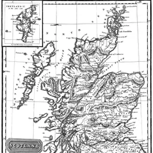
Metal Print : Map of Scotland, 1902. Creator: Unknown


![]()
Metal Prints from Heritage Images
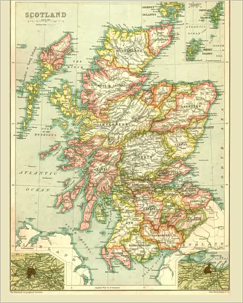
Map of Scotland, 1902. Creator: Unknown
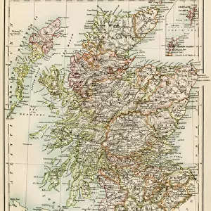
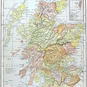
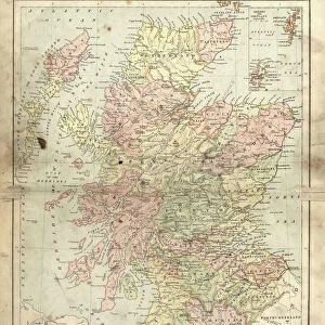
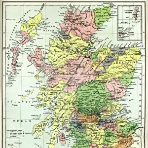
Map of Scotland, 1902. Showing the various counties and islands including the Hebrides, the Shetlands and the Orkneys, and an inset of the rail networks of Glasgow and Edinburgh. From The Century Atlas of the World. [John Walker & Co, Ltd. London, 1902]
Heritage Images features heritage image collections
Media ID 15512564
© The Print Collector / Heritage-Images
Counties County Edinburgh Geographical Institute Hebrides Orkney Islands Orkneys Shetland Islands
16"x20" (51x41cm) Metal Print
Discover the rich history and intricate detail of Scotland with our stunning Metal Print of a vintage map from 1902. This captivating piece, sourced from Heritage Images and created by an unknown artist, showcases the diverse landscape of Scotland, including its counties, islands such as the Hebrides, Shetlands, and Orkneys, and an inset of the rail networks in Glasgow and Edinburgh. Bring the beauty of Scotland's past into your home or office with this unique and eye-catching Metal Print. Experience the vintage charm and superior quality of our Metal Prints, which are waterproof, scratch-resistant, and UV-protected, ensuring your treasure lasts a lifetime.
Made with durable metal and luxurious printing techniques, our metal photo prints go beyond traditional canvases, adding a cool, modern touch to your space. Wall mount on back. Eco-friendly 100% post-consumer recycled ChromaLuxe aluminum surface. The thickness of the print is 0.045". Featuring a Scratch-resistant surface and Rounded corners. Backing hangers are attached to the back of the print and float the print 1/2-inch off the wall when hung, the choice of hanger may vary depending on size and International orders will come with Float Mount hangers only. Finished with a brilliant white high gloss surface for unsurpassed detail and vibrance. Printed using Dye-Sublimation and for best care we recommend a non-ammonia glass cleaner, water, or isopropyl (rubbing) alcohol to prevent harming the print surface. We recommend using a clean, lint-free cloth to wipe off the print. The ultra-hard surface is scratch-resistant, waterproof and weatherproof. Avoid direct sunlight exposure.
Made with durable metal and luxurious printing techniques, metal prints bring images to life and add a modern touch to any space
Estimated Image Size (if not cropped) is 40.6cm x 50.8cm (16" x 20")
Estimated Product Size is 41.2cm x 51.4cm (16.2" x 20.2")
These are individually made so all sizes are approximate
Artwork printed orientated as per the preview above, with portrait (vertical) orientation to match the source image.
FEATURES IN THESE COLLECTIONS
> Europe
> United Kingdom
> Scotland
> Edinburgh
> Edinburgh
> Europe
> United Kingdom
> Scotland
> Edinburgh
> Europe
> United Kingdom
> Scotland
> Glasgow
> Europe
> United Kingdom
> Scotland
> Lothian
> Edinburgh
> Europe
> United Kingdom
> Scotland
> Maps
> Europe
> United Kingdom
> Scotland
> Orkney
> Europe
> United Kingdom
> Scotland
> Posters
> Europe
> United Kingdom
> Scotland
> Related Images
> Europe
> United Kingdom
> Scotland
> Strathclyde
> Glasgow
> Maps and Charts
> Related Images
EDITORS COMMENTS
This print showcases a remarkable piece of history - the Map of Scotland from 1902. Created by an unknown cartographer, this map provides a detailed depiction of the various counties and islands that make up this enchanting country. From the Hebrides to the Shetlands and Orkneys, every corner is meticulously illustrated, offering a glimpse into Scotland's diverse geography. What makes this print even more fascinating is its inclusion of an inset showcasing the rail networks in Glasgow and Edinburgh. This additional detail highlights the importance of transportation during that era and offers insights into how these major cities were connected. The Century Atlas of the World, published by John Walker & Co in London, was renowned for its accuracy and attention to detail. The Edinburgh Geographical Institute played a crucial role in ensuring that this map accurately represented Scotland's geographical features. As we gaze upon this colorful snapshot from over a century ago, we are transported back in time to an era when maps were not just navigational tools but also works of art. With each county carefully delineated and every island precisely marked, it serves as both a historical document and a testament to human curiosity about our world. This print is truly an invaluable treasure for anyone interested in Scottish history or cartography enthusiasts seeking glimpses into past mapping techniques.
MADE IN THE USA
Safe Shipping with 30 Day Money Back Guarantee
FREE PERSONALISATION*
We are proud to offer a range of customisation features including Personalised Captions, Color Filters and Picture Zoom Tools
SECURE PAYMENTS
We happily accept a wide range of payment options so you can pay for the things you need in the way that is most convenient for you
* Options may vary by product and licensing agreement. Zoomed Pictures can be adjusted in the Cart.