Canvas Print > Europe > Spain > Maps
Canvas Print : Barcelona (19th c. ). Geometrical map, by Jos項
. Geometrical map, by Jos項")

. Geometrical map, by Jos項")


![]()
Canvas Prints from Mary Evans Picture Library
Barcelona (19th c. ). Geometrical map, by Jos項
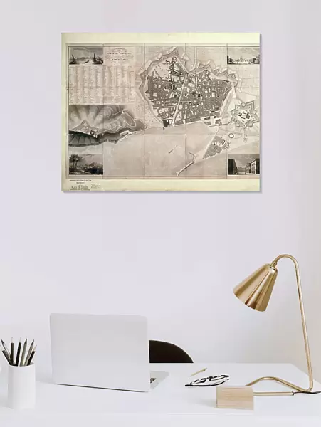
Barcelona (19th c.). Geometrical map, by Jos頍 as y Vila. SPAIN. Barcelona. Historical Archive of Barcelona
Mary Evans Picture Library makes available wonderful images created for people to enjoy over the centuries
Media ID 8269179
© Mary Evans Picture Library 2015 - https://copyrighthub.org/s0/hub1/creation/maryevans/MaryEvansPictureID/10685843
Archive Barcelona Cartographic Cartographies Cartography Citadel Engravings Geometrical Maps Planning Vila Walled Walls
20"x16" (51x41cm) Canvas Print
Discover the captivating allure of Barcelona's rich history with our exquisite Canvas Print of "Barcelona (19th c.). Geometrical map, by Jos項 as Vila" from the Media Storehouse collection. This stunning vintage map, sourced from the Historical Archive of Barcelona and available through Mary Evans Prints Online, showcases Barcelona's intricate geometrical layout during the 19th century. Each canvas print is meticulously crafted with premium materials and vibrant, fade-resistant inks, ensuring a timeless addition to your home or office decor. Immerse yourself in the charm of Barcelona's history and add a touch of old-world elegance to your space.
Delivered stretched and ready to hang our premium quality canvas prints are made from a polyester/cotton blend canvas and stretched over a 1.25" (32mm) kiln dried knot free wood stretcher bar. Packaged in a plastic bag and secured to a cardboard insert for safe transit.
Canvas Prints add colour, depth and texture to any space. Professionally Stretched Canvas over a hidden Wooden Box Frame and Ready to Hang
Estimated Product Size is 50.8cm x 40.6cm (20" x 16")
These are individually made so all sizes are approximate
Artwork printed orientated as per the preview above, with landscape (horizontal) orientation to match the source image.
FEATURES IN THESE COLLECTIONS
> Europe
> Spain
> Related Images
> Maps and Charts
> Early Maps
> Maps and Charts
> Related Images
> Maps and Charts
> Spain
MADE IN THE USA
Safe Shipping with 30 Day Money Back Guarantee
FREE PERSONALISATION*
We are proud to offer a range of customisation features including Personalised Captions, Color Filters and Picture Zoom Tools
SECURE PAYMENTS
We happily accept a wide range of payment options so you can pay for the things you need in the way that is most convenient for you
* Options may vary by product and licensing agreement. Zoomed Pictures can be adjusted in the Cart.