Canvas Print : Map of the Belgian frontier with forts, World War One


![]()
Canvas Prints from Mary Evans Picture Library
Map of the Belgian frontier with forts, World War One
Map of the Belgian frontier with forts at the beginning of World War One. Date: 1914
Mary Evans Picture Library makes available wonderful images created for people to enjoy over the centuries
Media ID 14125874
© Mary Evans Picture Library/PHILIP TALMAGE
Belgian Countries Forts Frontier Holland Maps
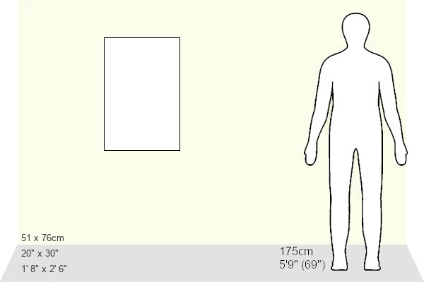
30"x20" (76x51cm) Canvas Print
Step back in time with our stunning Canvas Print of the Belgian frontier map from the beginning of World War One. This exclusive design, sourced from Mary Evans Prints Online, showcases intricate details of the fortified borders in 1914. Bring history into your home or office with this beautifully printed and framed canvas, perfect for history enthusiasts and those seeking a unique conversation starter. The high-quality canvas material and vibrant colors bring out the intricate details of the map, making it a captivating addition to any space. Order now and relive the past with this exquisite piece of art.
Delivered stretched and ready to hang our premium quality canvas prints are made from a polyester/cotton blend canvas and stretched over a 1.25" (32mm) kiln dried knot free wood stretcher bar. Packaged in a plastic bag and secured to a cardboard insert for safe transit.
Canvas Prints add colour, depth and texture to any space. Professionally Stretched Canvas over a hidden Wooden Box Frame and Ready to Hang
Estimated Product Size is 50.8cm x 76.2cm (20" x 30")
These are individually made so all sizes are approximate
Artwork printed orientated as per the preview above, with portrait (vertical) orientation to match the source image.
EDITORS COMMENTS
This historic map print depicts the Belgian frontier at the onset of World War One in 1914. The intricate detailing highlights the strategic fortifications along the border, which played a pivotal role in the early stages of the war. The map illustrates the complex web of alliances and territories in Europe during this tumultuous period. At the center of the map, the Belgian fortifications, including the strongholds of Liege, Namur, and Antwerp, are clearly marked. These fortifications were designed to protect Belgium from external threats and were considered some of the most advanced and impregnable in Europe at the time. However, they were ultimately breached by German forces in August 1914, marking a significant turning point in the war. The map also shows the neighboring countries of France, Germany, and Holland, emphasizing the interconnectedness of Europe's political landscape. The intricate border lines and annotations provide a glimpse into the complex web of alliances and tensions that fueled the outbreak of war. This map offers a unique perspective on the geopolitical situation in Europe at the beginning of World War One, providing valuable context for understanding the events that unfolded during this pivotal period in history. The intricate detailing and historical significance make this map a fascinating addition to any collection of World War One memorabilia or European history.
MADE IN THE USA
Safe Shipping with 30 Day Money Back Guarantee
FREE PERSONALISATION*
We are proud to offer a range of customisation features including Personalised Captions, Color Filters and Picture Zoom Tools
SECURE PAYMENTS
We happily accept a wide range of payment options so you can pay for the things you need in the way that is most convenient for you
* Options may vary by product and licensing agreement. Zoomed Pictures can be adjusted in the Cart.