Canvas Print > Africa > Botswana > Maps
Canvas Print : Map of Southern Africa


![]()
Canvas Prints from Mary Evans Picture Library
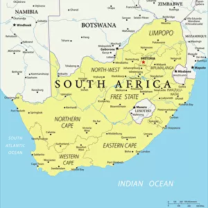
Map of Southern Africa
A map of Southern Africa, showing Natal and the Cape Colony. Date: 1885
Mary Evans Picture Library makes available wonderful images created for people to enjoy over the centuries
Media ID 20140929
© Bubblepunk
1885 Bechuanaland Botswana Cape Colonialism Colony Maps Natal Southern Territory Bechuana
20"x16" (51x41cm) Canvas Print
Bring the historical charm of 1885 into your home with our stunning Canvas Print of Southern Africa from Media Storehouse. This exquisite piece, sourced from Mary Evans Prints Online, showcases an intriguing map of the region, featuring Natal and the Cape Colony. Each Canvas Print is meticulously crafted with premium materials, ensuring vibrant colors and exceptional detail that truly bring the image to life. Add this captivating piece to your collection and transport yourself back in time.
Delivered stretched and ready to hang our premium quality canvas prints are made from a polyester/cotton blend canvas and stretched over a 1.25" (32mm) kiln dried knot free wood stretcher bar. Packaged in a plastic bag and secured to a cardboard insert for safe transit.
Canvas Prints add colour, depth and texture to any space. Professionally Stretched Canvas over a hidden Wooden Box Frame and Ready to Hang
Estimated Product Size is 50.8cm x 40.6cm (20" x 16")
These are individually made so all sizes are approximate
Artwork printed orientated as per the preview above, with landscape (horizontal) orientation to match the source image.
FEATURES IN THESE COLLECTIONS
> Africa
> Botswana
> Related Images
> Africa
> South Africa
> Maps
> Africa
> South Africa
> Related Images
> Maps and Charts
> Related Images
> Mary Evans Prints Online
> New Images July 2020
EDITORS COMMENTS
This map print, dating back to 1885, offers a glimpse into the geopolitical landscape of Southern Africa during the 1880s. The map meticulously delineates the territories of various European colonies and protectorates, including the prominent Natal and Cape Colony. At the time, European powers were aggressively expanding their territories in Africa, and this map reflects the growing influence of the British Empire in the region. The Cape Colony, established in 1652, is depicted in its expanded form, having annexed large swaths of land to the north and east. Natal, a British crown colony since 1845, is shown in the eastern part of the map, while the Bechuanaland Protectorate, later known as Botswana, is represented as a British territory to the north of the Cape Colony. The Bechuana people, also known as the Tswana, are the primary inhabitants of this region. The map also highlights other European territories, such as German South-West Africa (now Namibia) and Portuguese territories along the coast. The territorial claims and borders were not yet finalized, and the map serves as a testament to the dynamic and complex nature of colonialism in Southern Africa during the late 19th century. This map print is an essential historical document, providing valuable insights into the geopolitical landscape of Southern Africa during a pivotal period in its history. It offers a glimpse into the European powers' aggressive expansion and the impact of colonialism on the indigenous populations, shaping the political and demographic landscape of the region for generations to come.
MADE IN THE USA
Safe Shipping with 30 Day Money Back Guarantee
FREE PERSONALISATION*
We are proud to offer a range of customisation features including Personalised Captions, Color Filters and Picture Zoom Tools
SECURE PAYMENTS
We happily accept a wide range of payment options so you can pay for the things you need in the way that is most convenient for you
* Options may vary by product and licensing agreement. Zoomed Pictures can be adjusted in the Cart.