Photo Mug > Africa > Botswana > Maps
Photo Mug : Map of Southern Africa


![]()
Home Decor from Mary Evans Picture Library
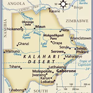
Map of Southern Africa
A map of Southern Africa, showing Natal and the Cape Colony. Date: 1885
Mary Evans Picture Library makes available wonderful images created for people to enjoy over the centuries
Media ID 20140929
© Bubblepunk
1885 Bechuanaland Botswana Cape Colonialism Colony Maps Natal Southern Territory Bechuana
Large Photo Mug (15 oz)
Bring the beauty of Southern Africa into your daily routine with our Media Storehouse Photo Mugs. Featuring an exquisite vintage map of the region from Mary Evans Prints Online, dated 1885, these mugs are not just functional but also a delight to behold. Perfect for tea or coffee, these high-quality mugs showcase intricate details of the map, making each sip an adventure. A thoughtful gift for travel enthusiasts, history buffs, or anyone who appreciates the charm of old maps. Order yours today and start your day with a journey to the heart of Southern Africa.
Elevate your coffee or tea experience with our premium white ceramic mug. Its wide, comfortable handle makes drinking easy, and you can rely on it to be both microwave and dishwasher safe. Sold in single units, preview may show both sides of the same mug so you can see how the picture wraps around.
Elevate your coffee or tea experience with our premium white ceramic mug. Its wide, comfortable handle makes drinking easy, and you can rely on it to be both microwave and dishwasher safe. Sold in single units, preview may show both sides of the same mug so you can see how the picture wraps around.
These are individually made so all sizes are approximate
FEATURES IN THESE COLLECTIONS
> Mary Evans Prints Online
> New Images July 2020
> Africa
> Botswana
> Related Images
> Africa
> South Africa
> Maps
> Africa
> South Africa
> Related Images
> Maps and Charts
> Related Images
EDITORS COMMENTS
This map print, dating back to 1885, offers a glimpse into the geopolitical landscape of Southern Africa during the 1880s. The map meticulously delineates the territories of various European colonies and protectorates, including the prominent Natal and Cape Colony. At the time, European powers were aggressively expanding their territories in Africa, and this map reflects the growing influence of the British Empire in the region. The Cape Colony, established in 1652, is depicted in its expanded form, having annexed large swaths of land to the north and east. Natal, a British crown colony since 1845, is shown in the eastern part of the map, while the Bechuanaland Protectorate, later known as Botswana, is represented as a British territory to the north of the Cape Colony. The Bechuana people, also known as the Tswana, are the primary inhabitants of this region. The map also highlights other European territories, such as German South-West Africa (now Namibia) and Portuguese territories along the coast. The territorial claims and borders were not yet finalized, and the map serves as a testament to the dynamic and complex nature of colonialism in Southern Africa during the late 19th century. This map print is an essential historical document, providing valuable insights into the geopolitical landscape of Southern Africa during a pivotal period in its history. It offers a glimpse into the European powers' aggressive expansion and the impact of colonialism on the indigenous populations, shaping the political and demographic landscape of the region for generations to come.
MADE IN THE USA
Safe Shipping with 30 Day Money Back Guarantee
FREE PERSONALISATION*
We are proud to offer a range of customisation features including Personalised Captions, Color Filters and Picture Zoom Tools
SECURE PAYMENTS
We happily accept a wide range of payment options so you can pay for the things you need in the way that is most convenient for you
* Options may vary by product and licensing agreement. Zoomed Pictures can be adjusted in the Cart.