Canvas Print > Europe > Spain > Politics
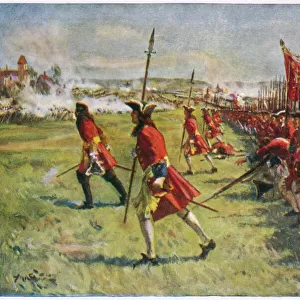
Canvas Print : Spanish Civil War Map Of Catalonia Regions And


![]()
Canvas Prints from Mary Evans Picture Library
Spanish Civil War Map Of Catalonia Regions And
spanish, civil, war, map, of, catalonia, regions, and, counties, october, poster, edited, by, the, regional, ministry, ecocomy, generalitat, spain, barcelona, biblioteca, de, catalunya, national, library, vertical, upright, colour, color, region, cartographic, cartographies, cartography, maps, boat, boats, craft, crafts, ship, ships, navy, spaniard, spaniards, europe, european, europeans, politics, policies, political, politician, politicians, public, institutions, institution, institutional, geographic, geographical, geography, Espana, history, historical, 10682846
Mary Evans Picture Library makes available wonderful images created for people to enjoy over the centuries
Media ID 32222370
© Mary Evans Picture Library 2015
Barcelona Biblioteca Cartographic Cartographies Cartography Catalonia Catalunya Counties Craft Crafts Edited Espana Generalitat Geographic Geographical Geography Institution Institutional Institutions Maps Ministry Policies Politicians Region Regional Regions Spaniard Spaniards Upright Europeans
20"x16" (51x41cm) Canvas Print
Step back in time with our captivating Canvas Prints from Media Storehouse, featuring an authentic Spanish Civil War Map of Catalonia Regions and Counties from Mary Evans Prints Online. This vintage October poster, edited by the Regional Ministry of Ecology and Generalitat of Catalonia, Spain, showcases intricate details of the Catalonia regions and counties during the Spanish Civil War. Bring the rich history of Barcelona and Biblioteca de Catalunya to your home or office with this stunning, high-quality Canvas Print. Order now and relive the past in vibrant colors and textures.
Delivered stretched and ready to hang our premium quality canvas prints are made from a polyester/cotton blend canvas and stretched over a 1.25" (32mm) kiln dried knot free wood stretcher bar. Packaged in a plastic bag and secured to a cardboard insert for safe transit.
Canvas Prints add colour, depth and texture to any space. Professionally Stretched Canvas over a hidden Wooden Box Frame and Ready to Hang
Estimated Product Size is 40.6cm x 50.8cm (16" x 20")
These are individually made so all sizes are approximate
Artwork printed orientated as per the preview above, with portrait (vertical) orientation to match the source image.
FEATURES IN THESE COLLECTIONS
> Europe
> Spain
> Related Images
> Maps and Charts
> Early Maps
> Maps and Charts
> Related Images
> Maps and Charts
> Spain
> People
> Politicians
> Mary Evans Prints Online
> New Images July 2023
EDITORS COMMENTS
This striking print showcases a Spanish Civil War map of Catalonia, highlighting the regions and counties during the tumultuous month of October. Edited by the regional ministry of economy in Generalitat, Spain, this poster is a historical artifact that sheds light on the political landscape of the time.
Displayed vertically and in vibrant color, this cartographic representation provides valuable insight into the geography and policies that shaped Spain during this period. The inclusion of boats and ships hints at the naval presence that played a role in these events, while also symbolizing the European influence on Spanish politics.
As we examine this piece, we are transported back to a time when politicians and public institutions were grappling with complex issues within Catalonia. The intricate details on this map speak volumes about the historical significance of Espana and its place within Europe.
Overall, this print serves as a reminder of Catalonia's rich history and its enduring impact on European politics. It is a testament to how geography can shape destinies and how maps can tell stories that resonate through generations.
MADE IN THE USA
Safe Shipping with 30 Day Money Back Guarantee
FREE PERSONALISATION*
We are proud to offer a range of customisation features including Personalised Captions, Color Filters and Picture Zoom Tools
SECURE PAYMENTS
We happily accept a wide range of payment options so you can pay for the things you need in the way that is most convenient for you
* Options may vary by product and licensing agreement. Zoomed Pictures can be adjusted in the Cart.