Canvas Print > Maps and Charts > Americas
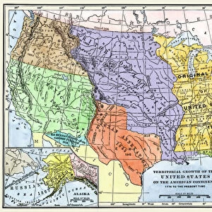
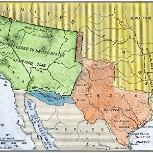
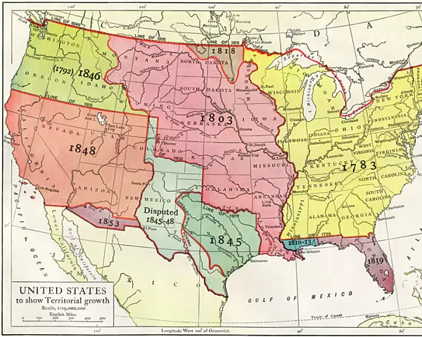
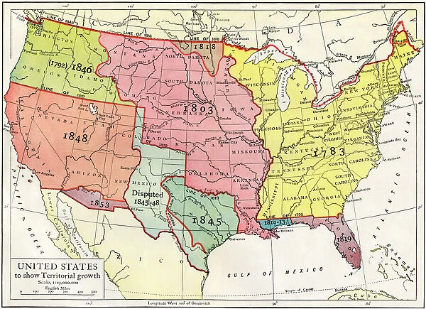
Canvas Print : Growth of the United States to 1853


![]()
Canvas Prints from North Wind
Growth of the United States to 1853
U.S. map, showing territorial growth to 1853.
Printed color lithograph of a 19th-century illustration
North Wind Picture Archives brings history to life with stock images and hand-colored illustrations
Media ID 5877442
© North Wind Picture Archives
13 Colonies 1700s 18th Century America Border Boundary Florida Louisiana Louisiana Purchase Louisiana Territory Northwest Territory Oregon Oregon Territory States Territory Texas
20"x16" (51x41cm) Canvas Print
"Add historical charm to your home or office with Media Storehouse's Canvas Print of "Growth of the United States to 1853" from North Wind Picture Archives. This captivating print showcases a colorful and intricately detailed lithograph map, illustrating the territorial expansion of the United States up to 1853. With its rich, textured canvas surface and vibrant colors, this timeless piece transports you back to the 19th century. A perfect conversation starter for history enthusiasts and collectors alike, this Canvas Print is sure to make an impressive addition to any space."
Delivered stretched and ready to hang our premium quality canvas prints are made from a polyester/cotton blend canvas and stretched over a 1.25" (32mm) kiln dried knot free wood stretcher bar. Packaged in a plastic bag and secured to a cardboard insert for safe transit.
Canvas Prints add colour, depth and texture to any space. Professionally Stretched Canvas over a hidden Wooden Box Frame and Ready to Hang
Estimated Product Size is 50.8cm x 40.6cm (20" x 16")
These are individually made so all sizes are approximate
Artwork printed orientated as per the preview above, with landscape (horizontal) orientation to match the source image.
FEATURES IN THESE COLLECTIONS
> Maps and Charts
> Related Images
> North America
> Related Images
> North Wind Picture Archives
> American history
> North Wind Picture Archives
> Maps
EDITORS COMMENTS
This print showcases the remarkable growth of the United States up until 1853. A beautifully colored lithograph, it depicts a 19th-century illustration that takes us on a journey through time and space. The map reveals the expansion of this great nation, highlighting its heritage and traditional values. The image transports us back to an era when borders were being redrawn and territories were being claimed. It captures the essence of American history, with each state marked in vibrant hues representing their unique identities. From the original 13 colonies to the vast expanse of land acquired through historical events such as the Louisiana Purchase and Gadsden Purchase, every inch tells a story. Florida's peninsula juts out prominently while Texas stands proudly as an independent republic before joining the Union. The Oregon Territory stretches towards the Pacific Northwest, showcasing America's westward ambitions. And who can forget about Louisiana? Its massive territory dominates much of this visual narrative. This vintage print serves as both a work of art and an educational tool, allowing us to appreciate how far we have come as a nation. It reminds us that our country's growth was not just physical but also symbolic - expanding horizons and embracing new frontiers throughout history.
MADE IN THE USA
Safe Shipping with 30 Day Money Back Guarantee
FREE PERSONALISATION*
We are proud to offer a range of customisation features including Personalised Captions, Color Filters and Picture Zoom Tools
SECURE PAYMENTS
We happily accept a wide range of payment options so you can pay for the things you need in the way that is most convenient for you
* Options may vary by product and licensing agreement. Zoomed Pictures can be adjusted in the Cart.