Home > North America > Puerto Rico > Maps
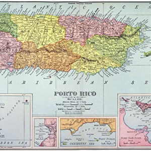
18th century map of Central America and the Gulf of Mexico engraved by Balthasar Ruyter

![]()
Wall Art and Photo Gifts from Design Pics
18th century map of Central America and the Gulf of Mexico engraved by Balthasar Ruyter
Design Pics offers Distinctively Different Imagery representing over 1,500 contributors
Media ID 24903269
© Ken Welsh / Design Pics
18th Century Central America Cuba Florida Geographical Geography Gulf Of Mexico Islands Jamaica Venezuela Hispaniola Puerto Rico
FEATURES IN THESE COLLECTIONS
> Maps and Charts
> Early Maps
> North America
> Cuba
> Maps
> North America
> Cuba
> Related Images
> North America
> Jamaica
> Maps
> North America
> Jamaica
> Related Images
> North America
> Mexico
> Maps
> North America
> Mexico
> Related Images
> North America
> Puerto Rico
> Maps
> North America
> Puerto Rico
> Related Images
EDITORS COMMENTS
This vibrant and meticulously detailed 18th-century map of Central America and the Gulf of Mexico, engraved by Balthasar Ruyter, is a captivating piece that transports us back in time. The rich colors and intricate illustrations bring to life the geographical wonders and historical significance of this region. As we explore the map, our eyes are drawn to Cuba, an island steeped in culture and history. Its unique shape stands out amidst a sea of smaller islands scattered throughout the Gulf of Mexico. To its east lies Hispaniola, home to both Haiti and the Dominican Republic. Further south, we encounter Puerto Rico with its distinctive outline. Moving westward, we find Jamaica – known for its lush landscapes and reggae rhythms. Venezuela's northern coast stretches across the bottom edge of this remarkable depiction. The inclusion of Florida reminds us that even during this era, it held strategic importance as a gateway between North America and these tropical lands further south. This archival print serves not only as a beautiful decorative piece but also as a valuable resource for historians and geographers alike. It allows us to delve into centuries-old cartography techniques while appreciating how knowledge about these regions has evolved over time. Whether you have an interest in history or simply appreciate stunning artwork, this 18th-century map will undoubtedly captivate your imagination with its vivid colors, attention to detail, and glimpse into our world's past.
MADE IN THE USA
Safe Shipping with 30 Day Money Back Guarantee
FREE PERSONALISATION*
We are proud to offer a range of customisation features including Personalised Captions, Color Filters and Picture Zoom Tools
SECURE PAYMENTS
We happily accept a wide range of payment options so you can pay for the things you need in the way that is most convenient for you
* Options may vary by product and licensing agreement. Zoomed Pictures can be adjusted in the Cart.