Home > Animals > Mammals > Muridae > Plains Mouse
Globe South America, True Colour Satellite Image. Earth. True colour satellite image of the Earth, c

![]()
Wall Art and Photo Gifts from Design Pics
Globe South America, True Colour Satellite Image. Earth. True colour satellite image of the Earth, c
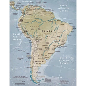
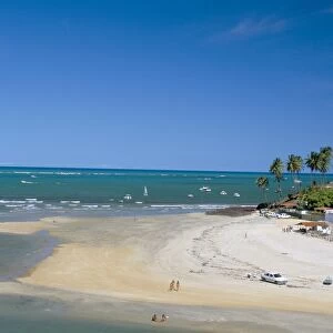
Globe South America, True Colour Satellite Image. Earth. True colour satellite image of the Earth, centred on South America. North is at top. Water is blue, vegetation is green, arid areas are brown, and snow and ice are white. Both land and ocean floor topography are shown. The terrain of South America is marked by the Andes mountains along the western coast, tropical rainforests (dark green) in the Amazon river basin in the north, and swamps and plains (lighter green) in the south. Surrounding South America (clockwise from upper left) is North America and the Caribbean islands, the Atlantic Ocean (right) and the Pacific Ocean (left). Parts of Greenland, Europe, Africa and Antarctica are also seen on the edges of the globe. The image used data from LANDSAT 5 & 7 satellites. Print size 42x42cm
Design Pics offers Distinctively Different Imagery representing over 1,500 contributors
Media ID 24589175
© UIG / Design Pics
Continent Environment Geographic Illustration Globe Satellite Image South America Uig Premium 1 Uig1 Satellite And Aerial World
FEATURES IN THESE COLLECTIONS
> Aerial Photography
> America
> Aerial Photography
> Related Images
> Africa
> South Africa
> Maps
> Africa
> South Africa
> Related Images
> Animals
> Mammals
> Muridae
> Plains Mouse
> Design Pics
> Design Pics Art
> Design Pics
> Universal Images Group
> Design Pics
> Update - March 23, 2022
> Europe
> France
> Canton
> Landes
> Maps and Charts
> World
EDITORS COMMENTS
This print showcases a true color satellite image of the Earth, with South America taking center stage. The stunning visual captures the continent's diverse terrain and natural beauty in remarkable detail. As you gaze upon this print, your eyes are drawn to the majestic Andes mountains that trace along South America's western coast, serving as a testament to nature's grandeur. The vibrant hues bring life to the image - from the lush green tropical rainforests of the Amazon river basin in the north to the lighter green swamps and plains in the south. The blue shades represent vast bodies of water while brown signifies arid regions, offering a comprehensive view of both land and ocean floor topography. Beyond South America lies an array of neighboring continents and oceans. From North America and its Caribbean islands on one side, to Europe, Africa, Greenland, and even Antarctica on its edges – this globe provides a glimpse into our interconnected world. Measuring 42x42cm in size, this print is perfect for those who appreciate geography or have an interest in exploring different parts of our planet. It was created using data collected by LANDSAT 5 & 7 satellites – technology that allows us to witness Earth's wonders from above. Whether displayed at home or office spaces, this print serves as a reminder of our planet's incredible diversity and invites us all to embark on new adventures across continents.
MADE IN THE USA
Safe Shipping with 30 Day Money Back Guarantee
FREE PERSONALISATION*
We are proud to offer a range of customisation features including Personalised Captions, Color Filters and Picture Zoom Tools
SECURE PAYMENTS
We happily accept a wide range of payment options so you can pay for the things you need in the way that is most convenient for you
* Options may vary by product and licensing agreement. Zoomed Pictures can be adjusted in the Cart.