Home > North America > United States of America > New York > New York > Maps
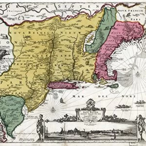
Map of New Belgium with a View of New Amsterdam, compiled by Nicolaes Visscher (1618-1709

![]()
Wall Art and Photo Gifts from Fine Art Finder
Map of New Belgium with a View of New Amsterdam, compiled by Nicolaes Visscher (1618-1709
NYH188439 Map of New Belgium with a View of New Amsterdam, compiled by Nicolaes Visscher (1618-1709) c.1651-55 (hand coloured engraving) by Jansson, Joannes (1588-1664); Collection of the New-York Historical Society, USA; eNew York Historical Society; Dutch, out of copyright
Media ID 22932204
© New York Historical Society / Bridgeman Images
Atlantic Ocean Cartouche Diagram
FEATURES IN THESE COLLECTIONS
> Arts
> Artists
> J
> Joannes Jansson
> Arts
> Artists
> O
> Oceanic Oceanic
> Europe
> Belgium
> Related Images
> Fine Art Finder
> Artists
> American School
> Fine Art Finder
> Artists
> Joannes Jansson
> Fine Art Finder
> Maps (celestial & Terrestrial)
> Maps and Charts
> Early Maps
> North America
> United States of America
> Maps
> North America
> United States of America
> New York
> New York
> Maps
EDITORS COMMENTS
This print showcases the "Map of New Belgium with a View of New Amsterdam" compiled by Nicolaes Visscher (1618-1709) in the mid-17th century. The hand-colored engraving, created by Joannes Jansson (1588-1664), offers a glimpse into the rich history and geographical layout of this region. The map presents an intricate diagram that spans across the East Coast of America, stretching from Novi Belgii to the Atlantic Ocean. It provides a comprehensive plan of Nieuw Amsterdam, now known as New York City, highlighting its strategic location and importance during that era. With its detailed cartouche and meticulous engravings, this artwork transports us back in time to witness the early development and exploration of these lands. The vibrant colors breathe life into each element on display, capturing our imagination as we explore every nook and cranny depicted on this historical map. As we delve deeper into this image, it becomes evident that it is not just a mere representation but also an invaluable piece of cultural heritage. Preserved within the collection of the New-York Historical Society in the USA, it serves as a testament to our collective past and reminds us of how far we have come. Through this remarkable engraving by Bridgeman Images, we are invited to appreciate both the artistic prowess involved in creating such intricate maps and their significance in unraveling our shared history.
MADE IN THE USA
Safe Shipping with 30 Day Money Back Guarantee
FREE PERSONALISATION*
We are proud to offer a range of customisation features including Personalised Captions, Color Filters and Picture Zoom Tools
SECURE PAYMENTS
We happily accept a wide range of payment options so you can pay for the things you need in the way that is most convenient for you
* Options may vary by product and licensing agreement. Zoomed Pictures can be adjusted in the Cart.