Home > Europe > United Kingdom > Northern Ireland > Maps
Map of the settlements of Angles, Saxons and Jutes in Britain c. 600 (print)
")
![]()
Wall Art and Photo Gifts from Fine Art Finder
Map of the settlements of Angles, Saxons and Jutes in Britain c. 600 (print)
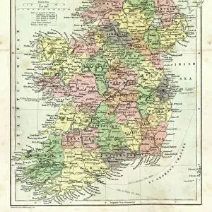
2603521 Map of the settlements of Angles, Saxons and Jutes in Britain c. 600 (print); (add.info.: From Historical Atlas, published 1923.)
Media ID 38109492
© Bridgeman Images
7 Century 7th Century 7th Century Century Angles Areas C7th Chart Claim Claims Countries Geographical Saxons Settlements Seventh Century Seventh Century Ad Sixth Territorial Territory Vii Century Viith Century 1920s 20s 20s Geographer Jutes
FEATURES IN THESE COLLECTIONS
> Europe
> Republic of Ireland
> Maps
> Europe
> United Kingdom
> England
> Maps
> Europe
> United Kingdom
> Maps
> Europe
> United Kingdom
> Northern Ireland
> Maps
> Europe
> United Kingdom
> Northern Ireland
> Posters
> Europe
> United Kingdom
> Northern Ireland
> Related Images
> Fine Art Finder
> Artists
> Dante Gabriel Charles Rossetti
> Maps and Charts
> Early Maps
EDITORS COMMENTS
This stunning print showcases a detailed map of the settlements of Angles, Saxons, and Jutes in Britain around the 7th century. The intricate lines and colors bring to life the historical landscape of early medieval England. From the Historical Atlas published in 1923, this piece captures a pivotal moment in British history.
The divisions of territory are clearly marked, showing where each group established their presence and influence during this time period. It's fascinating to see how these ancient civilizations carved out their own spaces within what would eventually become modern-day Great Britain.
The vibrant colors used in this print add an extra layer of depth and intrigue to the map, making it visually captivating as well as informative. As you study the intricacies of each settlement and boundary line, you can't help but be transported back in time to a world vastly different from our own.
Whether you're a history buff or simply appreciate beautiful artwork, this print is sure to spark your curiosity about the origins of British culture and society. It serves as a reminder of how far we've come since those early days while also honoring the legacy left behind by these ancient peoples.
MADE IN THE USA
Safe Shipping with 30 Day Money Back Guarantee
FREE PERSONALISATION*
We are proud to offer a range of customisation features including Personalised Captions, Color Filters and Picture Zoom Tools
SECURE PAYMENTS
We happily accept a wide range of payment options so you can pay for the things you need in the way that is most convenient for you
* Options may vary by product and licensing agreement. Zoomed Pictures can be adjusted in the Cart.