Home > Europe > United Kingdom > Scotland > Maps
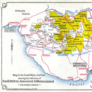
Map of Wales, showing the Coal Deposits (engraving)
")
![]()
Wall Art and Photo Gifts from Fine Art Finder
Map of Wales, showing the Coal Deposits (engraving)
7165959 Map of Wales, showing the Coal Deposits (engraving) by English School, (19th century); Private Collection; (add.info.: Map of Wales, showing the Coal Deposits. Illustration for A New and Popular Pictorial Description of England, Scotland, Ireland, Wales and the British Islands by Robert Sears (Robert Sears, 1847).); © Look and Learn
Media ID 24735804
© Look and Learn / Bridgeman Images
City Map City Plan General Map North Of Wales North Wales South Wales Street Plan Welsh
FEATURES IN THESE COLLECTIONS
> Arts
> Artists
> I
> Irish School Irish School
> Arts
> Artists
> W
> Robert White
> Arts
> Modern art pieces
> Pop art
> Street art
> Arts
> Portraits
> Pop art gallery
> Street art portraits
> Europe
> Republic of Ireland
> Maps
> Europe
> United Kingdom
> England
> Maps
> Europe
> United Kingdom
> Maps
> Europe
> United Kingdom
> Scotland
> Maps
> Europe
> United Kingdom
> Scotland
> Posters
> Fine Art Finder
> Artists
> English School
EDITORS COMMENTS
This engraving, titled "Map of Wales, showing the Coal Deposits" takes us back to 19th century Europe and provides a fascinating glimpse into the industrial history of Great Britain. The intricate illustration, created by an anonymous English School artist, showcases the coal-rich landscape of Wales with meticulous detail. Taken from Robert Sears' renowned publication "A New and Popular Pictorial Description of England, Scotland, Ireland, Wales and the British Islands" in 1847, this map offers a comprehensive overview of the country's coal deposits during that time. It serves as a testament to Wales' significant role in fueling Britain's Industrial Revolution. The print transports us to a bygone era when mining was at its peak in South Wales and North Wales. With its precise city plans and street layouts incorporated into the general map, it invites us to explore these regions through our senses. As we study this historical artifact closely, we can almost envision bustling towns surrounded by vast stretches of coal mines. The monochromatic palette adds depth to this visual narrative while emphasizing the importance of these natural resources for both Welsh communities and the entire British Isles. This engraving not only captures an essential aspect of Welsh heritage but also highlights how maps can be powerful tools for understanding our past. With Bridgeman Images preserving this remarkable piece from their private collection, we are fortunate enough to witness history unfold before our eyes through artistry that transcends time.
MADE IN THE USA
Safe Shipping with 30 Day Money Back Guarantee
FREE PERSONALISATION*
We are proud to offer a range of customisation features including Personalised Captions, Color Filters and Picture Zoom Tools
SECURE PAYMENTS
We happily accept a wide range of payment options so you can pay for the things you need in the way that is most convenient for you
* Options may vary by product and licensing agreement. Zoomed Pictures can be adjusted in the Cart.